Suez geodata
Suez is a seat of a first-order administrative division; located in Egypt in Africa/Cairo (GMT+2) time zone. With population of 488,125 people, there are 4 cities with bigger population in this country. Compared to other cities in Egypt, 53.6% of cities are located further ↑North; 82.6% of cities are located further ←West and 81.2% of cities have higher elevation than Suez. Note1


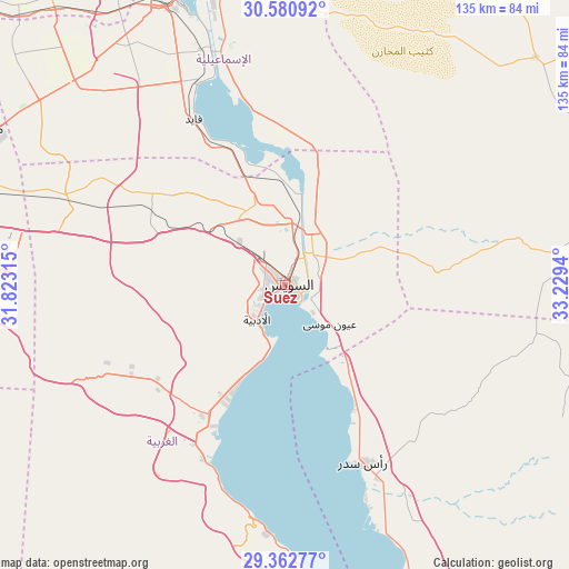
Suez GPS coordinates[2]
29° 58' 25.356" North, 32° 31' 34.572" East
| Map corner | latitude | longitude |
|---|---|---|
| Upper-left | 30.58092°, | 31.82315° |
| Center: | 29.97371°, | 32.52627° |
| Lower-right: | 29.36277°, | 33.2294° |
| Map W x H: | 135.4×135.4 km | = 84.1×84.1mi |
| max Lat: | 31.5084° ⇑53.6% North |
| Suez: | 29.97371° |
| min Lat: | ⇓46.4% South 22.3457° |
| min Long | Suez | max Long |
| 25.51965° | 32.52627° | 34.89572° |
| W 82.6%⇐ | ⇒17.4% E |
Elevation
Elevation of Suez is 11 m = 36 ft, and this is 32.5 m = 107 ft below average elevation for this country.
| Max E: |
1565 m = 5135 ft | 81.2% |
| Avg. | 43.5 m = 143 ft | |
| Suez | 11 m = 36 ft | |
Min E: |
-15 m = -49 ft | 18.8% |
See also: Suez elevation on elevation.city.
Geographical zone
Suez is located in North temperate zone (between Tropic of Cancer and the Arctic Circle). Distance of this Northern Tropic circle is 726.8 km =451.6 mi to South.| Distance of | km | miles | from Suez |
|---|---|---|---|
| North Pole | 6674.3 | 4147.2 | to North |
| Arctic Circle | 4068.4 | 2528 | to North |
| Tropic Cancer | 726.8 | 451.6 | to South |
| Equator | 3332.8 | 2070.9 | to South |


Nearby cities:
15 places around Suez: (largest is in red/bold)
• Abū Kabīr
117.1 km =72.8 mi,  315°
315°
• Ain Sukhna
46.2 km =28.7 mi,  205°
205°
• Al Khānkah
114.5 km =71.1 mi,  283°
283°
• Al Qurayn
104.3 km =64.8 mi,  313°
313°
• Al Ḩawāmidīyah
123.2 km =76.6 mi,  266°
266°
• At Tall al Kabīr
95.3 km =59.2 mi, 311°
• Bilbays
105.1 km =65.3 mi,  298°
298°
• Fāqūs
109.2 km =67.9 mi, 320°
• Hihyā
118.9 km =73.9 mi, 310°
• Ismailia
74.2 km =46.1 mi,  340°
340°
• Mashtūl as Sūq
118.5 km =73.6 mi,  291°
291°
• New Cairo
101.9 km =63.3 mi, 273°
• Shibīn al Qanāṭir
121.9 km =75.7 mi, 288°
• Zagazig
119.7 km =74.4 mi, 304°
• Ḩalwān
119 km =73.9 mi,  262°
262°
Sources, notices
• [Note1] Compared only with cities in Egypt existing in our database
• [Src1] Map data: © OpenStreetMap contributors (CC-BY-SA)
• [Src2] Other city data from geonames.org with taken over terms of usage.
• [Src3] Geographical zone / Annual Mean Temperature by Robert A. Rohde @ Wikipedia
