Samannūd geodata
Samannūd (Gharbia) is a populated place; located in Egypt in Africa/Cairo (GMT+2) time zone. With population of 54,980 people, there are 78 cities with bigger population in this country. Compared to other cities in Egypt, 76.8% of cities are located further ↓South; 55.1% of cities are located further →East and 73.9% of cities have higher elevation than Samannūd. Note1


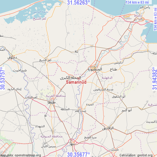
Samannūd GPS coordinates[2]
30° 57' 41.76" North, 31° 14' 26.484" East
| Map corner | latitude | longitude |
|---|---|---|
| Upper-left | 31.56263°, | 30.53757° |
| Center: | 30.9616°, | 31.24069° |
| Lower-right: | 30.35677°, | 31.94382° |
| Map W x H: | 134.1×134.1 km | = 83.3×83.3mi |
| max Lat: | 31.5084° ⇑23.2% North |
| Samannūd: | 30.9616° |
| min Lat: | ⇓76.8% South 22.3457° |
| min Long | Samannūd | max Long |
| 25.51965° | 31.24069° | 34.89572° |
| W 44.9%⇐ | ⇒55.1% E |
Elevation
Elevation of Samannūd is 12 m = 39 ft, and this is 31.5 m = 103 ft below average elevation for this country.
| Max E: |
1565 m = 5135 ft | 73.9% |
| Avg. | 43.5 m = 143 ft | |
| Samannūd | 12 m = 39 ft | |
Min E: |
-15 m = -49 ft | 26.1% |
See also: Samannūd elevation on elevation.city.
Geographical zone
Samannūd is located in North temperate zone (between Tropic of Cancer and the Arctic Circle). Distance of this Northern Tropic circle is 836.7 km =519.9 mi to South.| Distance of | km | miles | from Samannūd |
|---|---|---|---|
| North Pole | 6564.5 | 4079 | to North |
| Arctic Circle | 3958.6 | 2459.8 | to North |
| Tropic Cancer | 836.7 | 519.9 | to South |
| Equator | 3442.6 | 2139.1 | to South |


Nearby cities:
15 places around Samannūd: (largest is in red/bold)
• Ajā
5.2 km =3.2 mi,  115°
115°
• Al Ibrāhīmīyah
40.9 km =25.4 mi,  131°
131°
• Al Manşūrah
15.7 km =9.8 mi,  58°
58°
• Al Maḩallah al Kubrá
7.1 km =4.4 mi,  278°
278°
• Al Ḩāmūl
39.9 km =24.8 mi,  347°
347°
• Basyūn
40.8 km =25.4 mi,  266°
266°
• Bilqās
30.3 km =18.8 mi,  21°
21°
• Dikirnis
36.6 km =22.7 mi,  67°
67°
• Diyarb Najm
29.9 km =18.6 mi,  140°
140°
• Kafr ash Shaykh
33.2 km =20.6 mi,  300°
300°
• Quţūr
27.2 km =16.9 mi, 272°
• Shirbīn
37.6 km =23.4 mi,  45°
45°
• Tanda
29.8 km =18.5 mi,  229°
229°
• Zefta
27.5 km =17.1 mi,  179°
179°
• Ţalkhā
16.6 km =10.3 mi, 51°
Sources, notices
• [Note1] Compared only with cities in Egypt existing in our database
• [Src1] Map data: © OpenStreetMap contributors (CC-BY-SA)
• [Src2] Other city data from geonames.org with taken over terms of usage.
• [Src3] Geographical zone / Annual Mean Temperature by Robert A. Rohde @ Wikipedia
