Samālūţ geodata
Samālūţ (Minya) is a populated place; located in Egypt in Africa/Cairo (GMT+2) time zone. With population of 90,465 people, there are 43 cities with bigger population in this country. Compared to other cities in Egypt, 71.7% of cities are located further ↑North; 85.5% of cities are located further →East and 73.2% of cities have lower elevation than Samālūţ. Note1


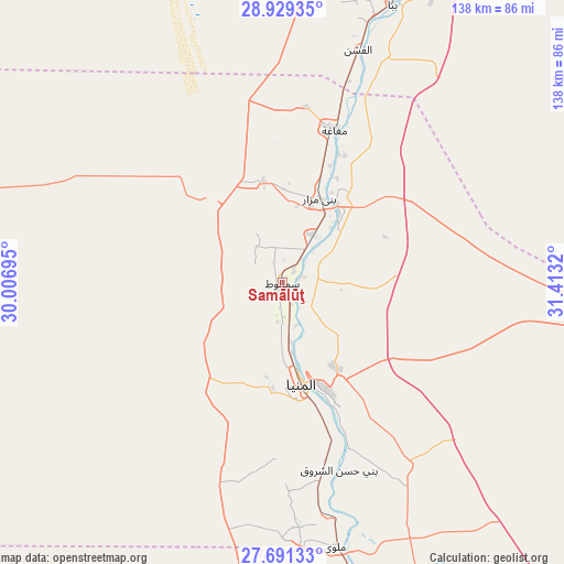
Samālūţ GPS coordinates[2]
28° 18' 43.704" North, 30° 42' 36.252" East
| Map corner | latitude | longitude |
|---|---|---|
| Upper-left | 28.92935°, | 30.00695° |
| Center: | 28.31214°, | 30.71007° |
| Lower-right: | 27.69133°, | 31.4132° |
| Map W x H: | 137.7×137.7 km | = 85.6×85.6mi |
| max Lat: | 31.5084° ⇑71.7% North |
| Samālūţ: | 28.31214° |
| min Lat: | ⇓28.3% South 22.3457° |
| min Long | Samālūţ | max Long |
| 25.51965° | 30.71007° | 34.89572° |
| W 14.5%⇐ | ⇒85.5% E |
Elevation
Elevation of Samālūţ is 41 m = 135 ft, and this is 2.5 m = 8 ft below average elevation for this country.
| Max E: |
1565 m = 5135 ft | 26.8% |
| Avg. | 43.5 m = 143 ft | |
| Samālūţ | 41 m = 135 ft | |
Min E: |
-15 m = -49 ft | 73.2% |
See also: Samālūţ elevation on elevation.city.
Geographical zone
Samālūţ is located in North temperate zone (between Tropic of Cancer and the Arctic Circle). Distance of this Northern Tropic circle is 542.1 km =336.8 mi to South.| Distance of | km | miles | from Samālūţ |
|---|---|---|---|
| North Pole | 6859 | 4262 | to North |
| Arctic Circle | 4253.2 | 2642.8 | to North |
| Tropic Cancer | 542.1 | 336.8 | to South |
| Equator | 3148 | 1956.1 | to South |


Nearby cities:
15 places around Samālūţ: (largest is in red/bold)
• Abū Qurqāş
44.2 km =27.5 mi,  163°
163°
• Al Fashn
59.9 km =37.2 mi,  17°
17°
• Al Fayyūm
111.7 km =69.4 mi,  6°
6°
• Al Minyā
22.8 km =14.2 mi,  170°
170°
• Al Qūşīyah
97.5 km =60.6 mi, 173°
• Banī Mazār
23 km =14.3 mi, 22°
• Banī Suwayf
92.8 km =57.7 mi, 24°
• Būsh
101.5 km =63.1 mi, 23°
• Dayr Mawās
75.7 km =47 mi, 169°
• Dayrūţ
84.6 km =52.6 mi, 173°
• Iţsā
103.2 km =64.1 mi,  4°
4°
• Mallawī
65.9 km =40.9 mi, 168°
• Manfalūţ
114.3 km =71 mi, 167°
• Maţāy
13.7 km =8.5 mi,  29°
29°
• Sumusţā as Sulţānī
68.6 km =42.6 mi, 11°
Sources, notices
• [Note1] Compared only with cities in Egypt existing in our database
• [Src1] Map data: © OpenStreetMap contributors (CC-BY-SA)
• [Src2] Other city data from geonames.org with taken over terms of usage.
• [Src3] Geographical zone / Annual Mean Temperature by Robert A. Rohde @ Wikipedia
