Alexandria geodata
Alexandria is a seat of a first-order administrative division; located in Egypt in Africa/Cairo (GMT+2) time zone. With population of 3,811,516 people, there is 1 city with bigger population in this country. Compared to other cities in Egypt, 89.9% of cities are located further ↓South; 96.4% of cities are located further →East and 86.2% of cities have higher elevation than Alexandria. Note1


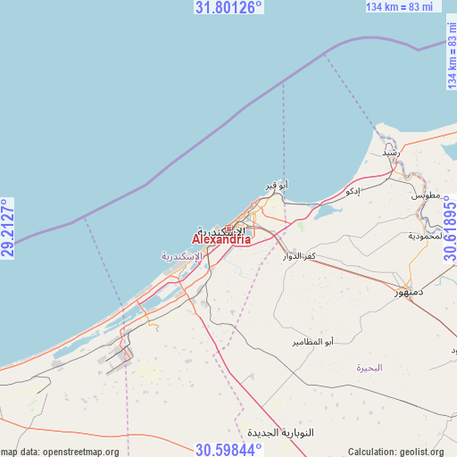
Alexandria GPS coordinates[2]
31° 12' 6.336" North, 29° 54' 56.952" East
| Map corner | latitude | longitude |
|---|---|---|
| Upper-left | 31.80126°, | 29.2127° |
| Center: | 31.20176°, | 29.91582° |
| Lower-right: | 30.59844°, | 30.61895° |
| Map W x H: | 133.7×133.7 km | = 83.1×83.1mi |
| max Lat: | 31.5084° ⇑10.1% North |
| Alexandria: | 31.20176° |
| min Lat: | ⇓89.9% South 22.3457° |
| min Long | Alexandria | max Long |
| 25.51965° | 29.91582° | 34.89572° |
| W 3.6%⇐ | ⇒96.4% E |
Elevation
Elevation of Alexandria is 9 m = 30 ft, and this is 34.5 m = 113 ft below average elevation for this country.
| Max E: |
1565 m = 5135 ft | 86.2% |
| Avg. | 43.5 m = 143 ft | |
| Alexandria | 9 m = 30 ft | |
Min E: |
-15 m = -49 ft | 13.8% |
See also: Alexandria elevation on elevation.city.
Geographical zone
Alexandria is located in North temperate zone (between Tropic of Cancer and the Arctic Circle). Distance of this Northern Tropic circle is 863.4 km =536.5 mi to South.| Distance of | km | miles | from Alexandria |
|---|---|---|---|
| North Pole | 6537.8 | 4062.4 | to North |
| Arctic Circle | 3931.9 | 2443.2 | to North |
| Tropic Cancer | 863.4 | 536.5 | to South |
| Equator | 3469.3 | 2155.7 | to South |


Nearby cities:
15 places around Alexandria: (largest is in red/bold)
• Abū al Maţāmīr
40.7 km =25.3 mi,  142°
142°
• Ad Dilinjāt
72.2 km =44.9 mi,  125°
125°
• Basyūn
90.3 km =56.1 mi,  108°
108°
• Beheira
86.6 km =53.8 mi,  151°
151°
• Damanhūr
55.8 km =34.7 mi, 109°
• Disūq
70.1 km =43.6 mi,  96°
96°
• Fuwwah
60.2 km =37.4 mi,  89°
89°
• Idkū
38.2 km =23.7 mi,  72°
72°
• Kafr ad Dawwār
21.7 km =13.5 mi, 110°
• Kafr az Zayyāt
95.6 km =59.4 mi,  115°
115°
• Kawm Ḩamādah
89.3 km =55.5 mi, 123°
• Munshāt ‘Alī Āghā
74.9 km =46.5 mi, 93°
• Rosetta
52.5 km =32.6 mi, 65°
• Sīdī Sālim
83.1 km =51.6 mi,  84°
84°
• Ḩawsh ‘Īsá
48 km =29.8 mi, 132°
In other languages:
- In Spanish: Alejandría
- In France: Alexandrie
- In Italian: Alessandria d'Egitto
- In Russian: Александрия
- In Chinese: 亞歷山卓, 亚历山大港
Sources, notices
• [Note1] Compared only with cities in Egypt existing in our database
• [Src1] Map data: © OpenStreetMap contributors (CC-BY-SA)
• [Src2] Other city data from geonames.org with taken over terms of usage.
• [Src3] Geographical zone / Annual Mean Temperature by Robert A. Rohde @ Wikipedia
