Zafarraya geodata
Zafarraya (Andalusia) is a seat of a third-order administrative division; located in Spain in Europe/Madrid (GMT+2) time zone. With population of 2,181 people, there are 2061 cities with bigger population in this country. Compared to other cities in Spain, 95.5% of cities are located further ↑North; 61.8% of cities are located further →East and 79.5% of cities have lower elevation than Zafarraya. Note1


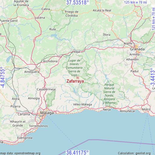
Zafarraya GPS coordinates[2]
36° 58' 31.944" North, 4° 8' 39.912" West
| Map corner | latitude | longitude |
|---|---|---|
| Upper-left | 37.53518°, | -4.84755° |
| Center: | 36.97554°, | -4.14442° |
| Lower-right: | 36.41175°, | -3.4413° |
| Map W x H: | 124.9×124.9 km | = 77.6×77.6mi |
| max Lat: | 43.74134° ⇑95.5% North |
| Zafarraya: | 36.97554° |
| min Lat: | ⇓4.5% South 27.64134° |
| min Long | Zafarraya | max Long |
| -18.00367° | -4.14442° | 4.2899° |
| W 38.2%⇐ | ⇒61.8% E |
Elevation
Elevation of Zafarraya is 893 m = 2930 ft, and this is 295 m = 968 ft above average elevation for this country.
| Max E: |
1682 m = 5518 ft | 20.5% |
| Zafarraya | 893 m 2930 ft | |
| Avg. | 598 m = 1962 ft | |
Min E: |
0 m = 0 ft | 79.5% |
See also: Spain elevation on elevation.city.
Geographical zone
Zafarraya is located in North temperate zone (between Tropic of Cancer and the Arctic Circle). Distance of this Northern Tropic circle is 1505.4 km =935.4 mi to South.| Distance of | km | miles | from Zafarraya |
|---|---|---|---|
| North Pole | 5895.8 | 3663.5 | to North |
| Arctic Circle | 3289.9 | 2044.2 | to North |
| Tropic Cancer | 1505.4 | 935.4 | to South |
| Equator | 4111.3 | 2554.6 | to South |


Nearby cities:
15 places around Zafarraya: (largest is in red/bold)
• Alcaucín
8.5 km =5.3 mi,  161°
161°
• Alfarnate
10.4 km =6.5 mi,  281°
281°
• Alfarnatejo
10.6 km =6.6 mi, 282°
• Alhama de Granada
14.2 km =8.8 mi,  75°
75°
• Benamargosa
16.2 km =10.1 mi,  195°
195°
• Canillas de Aceituno
12.7 km =7.9 mi,  154°
154°
• Colmenar
18.7 km =11.6 mi,  245°
245°
• Comares
16.7 km =10.4 mi,  212°
212°
• Cútar
17.6 km =10.9 mi, 204°
• Periana
6.6 km =4.1 mi,  219°
219°
• Ríogordo
14.7 km =9.1 mi,  243°
243°
• Salares
17.2 km =10.7 mi,  141°
141°
• Sedella
16 km =9.9 mi, 141°
• Villanueva del Trabuco
18.2 km =11.3 mi,  288°
288°
• Viñuela
12.5 km =7.8 mi,  178°
178°
Sources, notices
• [Note1] Compared only with cities in Spain existing in our database
• [Src1] Map data: © OpenStreetMap contributors (CC-BY-SA)
• [Src2] Other city data from geonames.org with taken over terms of usage.
• [Src3] Geographical zone / Annual Mean Temperature by Robert A. Rohde @ Wikipedia
