Alfarnatejo geodata
Alfarnatejo (Andalusia) is a seat of a third-order administrative division; located in Spain in Europe/Madrid (GMT+2) time zone. With population of 397 people, there are 4147 cities with bigger population in this country. Compared to other cities in Spain, 95.3% of cities are located further ↑North; 63.4% of cities are located further →East and 80.3% of cities have lower elevation than Alfarnatejo. Note1


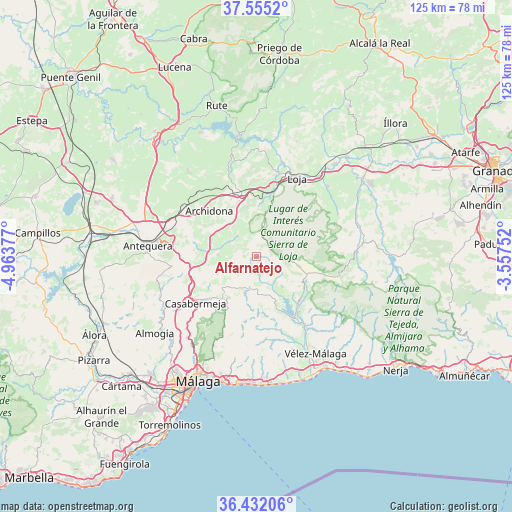
Alfarnatejo GPS coordinates[2]
36° 59' 44.52" North, 4° 15' 38.304" West
| Map corner | latitude | longitude |
|---|---|---|
| Upper-left | 37.5552°, | -4.96377° |
| Center: | 36.9957°, | -4.26064° |
| Lower-right: | 36.43206°, | -3.55752° |
| Map W x H: | 124.9×124.9 km | = 77.6×77.6mi |
| max Lat: | 43.74134° ⇑95.3% North |
| Alfarnatejo: | 36.9957° |
| min Lat: | ⇓4.7% South 27.64134° |
| min Long | Alfarnatejo | max Long |
| -18.00367° | -4.26064° | 4.2899° |
| W 36.6%⇐ | ⇒63.4% E |
Elevation
Elevation of Alfarnatejo is 900 m = 2953 ft, and this is 302 m = 991 ft above average elevation for this country.
| Max E: |
1682 m = 5518 ft | 19.7% |
| Alfarnatejo | 900 m 2953 ft | |
| Avg. | 598 m = 1962 ft | |
Min E: |
0 m = 0 ft | 80.3% |
See also: Spain elevation on elevation.city.
Geographical zone
Alfarnatejo is located in North temperate zone (between Tropic of Cancer and the Arctic Circle). Distance of this Northern Tropic circle is 1507.6 km =936.8 mi to South.| Distance of | km | miles | from Alfarnatejo |
|---|---|---|---|
| North Pole | 5893.5 | 3662 | to North |
| Arctic Circle | 3287.6 | 2042.8 | to North |
| Tropic Cancer | 1507.6 | 936.8 | to South |
| Equator | 4113.5 | 2556 | to South |


Nearby cities:
15 places around Alfarnatejo: (largest is in red/bold)
• Alcaucín
16.6 km =10.3 mi,  128°
128°
• Alfarnate
0.2 km =0.1 mi,  143°
143°
• Archidona
16 km =9.9 mi,  314°
314°
• Benamargosa
18.8 km =11.7 mi,  161°
161°
• Borge
20.2 km =12.6 mi,  173°
173°
• Casabermeja
18.9 km =11.7 mi,  232°
232°
• Colmenar
12.1 km =7.5 mi,  213°
213°
• Comares
16.3 km =10.1 mi,  175°
175°
• Cútar
18.5 km =11.5 mi, 170°
• Periana
9.6 km =6 mi, 140°
• Ríogordo
9.2 km =5.7 mi,  198°
198°
• Villanueva del Rosario
9.3 km =5.8 mi,  270°
270°
• Villanueva del Trabuco
7.8 km =4.8 mi,  297°
297°
• Viñuela
18.2 km =11.3 mi, 144°
• Zafarraya
10.6 km =6.6 mi,  102°
102°
Sources, notices
• [Note1] Compared only with cities in Spain existing in our database
• [Src1] Map data: © OpenStreetMap contributors (CC-BY-SA)
• [Src2] Other city data from geonames.org with taken over terms of usage.
• [Src3] Geographical zone / Annual Mean Temperature by Robert A. Rohde @ Wikipedia
