Vila-real geodata
Vila-real (Valencia) is a populated place; located in Spain in Europe/Madrid (GMT+2) time zone. With population of 51,205 people, there are 181 cities with bigger population in this country. Compared to other cities in Spain, 71.2% of cities are located further ↑North; 86.4% of cities are located further ←West and 91.5% of cities have higher elevation than Vila-real. Note1
Administrative division(s):
- Level 1: Valencia
- Level 2: Província de Castelló
- Level 3: Borriana/Burriana


Vila-real GPS coordinates[2]
39° 56' 17.88" North, 0° 6' 3.132" West
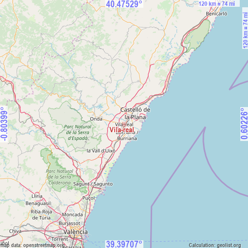
| Map corner | latitude | longitude |
|---|---|---|
| Upper-left | 40.47529°, | -0.80399° |
| Center: | 39.9383°, | -0.10087° |
| Lower-right: | 39.39707°, | 0.60226° |
| Map W x H: | 119.9×119.9 km | = 74.5×74.5mi |
| max Lat: | 43.74134° ⇑71.2% North |
| Vila-real: | 39.9383° |
| min Lat: | ⇓28.8% South 27.64134° |
| min Long | Vila-real | max Long |
| -18.00367° | -0.10087° | 4.2899° |
| W 86.4%⇐ | ⇒13.6% E |
Elevation
Elevation of Vila-real is 48 m = 157 ft, and this is 550 m = 1804 ft below average elevation for this country.
| Max E: |
1682 m = 5518 ft | 91.5% |
| Avg. | 598 m = 1962 ft | |
| Vila-real | 48 m = 157 ft | |
Min E: |
0 m = 0 ft | 8.5% |
See also: Vila-real elevation on elevation.city.
Geographical zone
Vila-real is located in North temperate zone (between Tropic of Cancer and the Arctic Circle). Distance of this Northern Tropic circle is 1834.8 km =1140.1 mi to South.| Distance of | km | miles | from Vila-real |
|---|---|---|---|
| North Pole | 5566.3 | 3458.7 | to North |
| Arctic Circle | 2960.5 | 1839.6 | to North |
| Tropic Cancer | 1834.8 | 1140.1 | to South |
| Equator | 4440.7 | 2759.3 | to South |


Nearby cities:
15 places around Vila-real: (largest is in red/bold)
• Almassora
3.4 km =2.1 mi,  72°
72°
• Alquerías del Niño Perdido
5.4 km =3.4 mi,  206°
206°
• Artana
14.4 km =8.9 mi,  248°
248°
• Betxí
8.5 km =5.3 mi,  266°
266°
• Borriol
11.9 km =7.4 mi,  12°
12°
• Burriana
5.6 km =3.5 mi,  166°
166°
• Castelló de la Plana
6.9 km =4.3 mi,  39°
39°
• El Grao
10.5 km =6.5 mi, 67°
• Moncofa
14.9 km =9.3 mi,  195°
195°
• Nules
10.5 km =6.5 mi, 206°
• Onda
13.9 km =8.6 mi,  282°
282°
• Ribesalbes
16.6 km =10.3 mi,  301°
301°
• San Juan de Moró
13.9 km =8.6 mi,  347°
347°
• Villavieja
12.1 km =7.5 mi,  215°
215°
• l'Alcora
16.6 km =10.3 mi,  329°
329°
Sources, notices
• [Note1] Compared only with cities in Spain existing in our database
• [Src1] Map data: © OpenStreetMap contributors (CC-BY-SA)
• [Src2] Other city data from geonames.org with taken over terms of usage.
• [Src3] Geographical zone / Annual Mean Temperature by Robert A. Rohde @ Wikipedia
