Villanueva de Mesía geodata
Villanueva de Mesía (Andalusia) is a seat of a third-order administrative division; located in Spain in Europe/Madrid (GMT+2) time zone. In our database, there are 6762 cities with bigger population. Compared to other cities in Spain, 93.9% of cities are located further ↑North; 59.9% of cities are located further →East and 62.1% of cities have higher elevation than Villanueva de Mesía. Note1
Administrative division(s):
- Level 1: Andalusia
- Level 2: Provincia de Granada
- Level 3: Villanueva Mesía


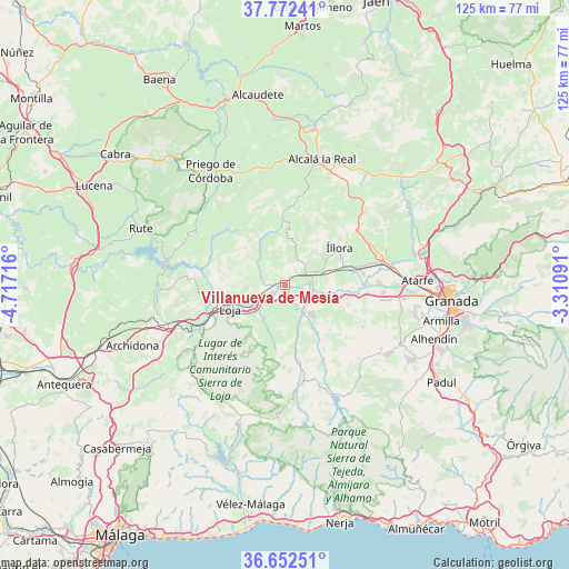
Villanueva de Mesía GPS coordinates[2]
37° 12' 52.344" North, 4° 0' 50.544" West
| Map corner | latitude | longitude |
|---|---|---|
| Upper-left | 37.77241°, | -4.71716° |
| Center: | 37.21454°, | -4.01404° |
| Lower-right: | 36.65251°, | -3.31091° |
| Map W x H: | 124.5×124.5 km | = 77.4×77.4mi |
| max Lat: | 43.74134° ⇑93.9% North |
| Villanueva de Mesía: | 37.21454° |
| min Lat: | ⇓6.1% South 27.64134° |
| min Long | Villanueva de M | max Long |
| -18.00367° | -4.01404° | 4.2899° |
| W 40.1%⇐ | ⇒59.9% E |
Elevation
Elevation of Villanueva de Mesía is 498 m = 1634 ft, and this is 100 m = 328 ft below average elevation for this country.
| Max E: |
1682 m = 5518 ft | 62.1% |
| Avg. | 598 m = 1962 ft | |
| Villanueva de Mesía | 498 m = 1634 ft | |
Min E: |
0 m = 0 ft | 37.9% |
See also: Spain elevation on elevation.city.
Geographical zone
Villanueva de Mesía is located in North temperate zone (between Tropic of Cancer and the Arctic Circle). Distance of this Northern Tropic circle is 1531.9 km =951.9 mi to South.| Distance of | km | miles | from Villanueva de Mesía |
|---|---|---|---|
| North Pole | 5869.2 | 3647 | to North |
| Arctic Circle | 3263.3 | 2027.7 | to North |
| Tropic Cancer | 1531.9 | 951.9 | to South |
| Equator | 4137.9 | 2571.2 | to South |


Nearby cities:
15 places around Villanueva de Mesía: (largest is in red/bold)
• Algarinejo
17.7 km =11 mi,  313°
313°
• Chauchina
21.5 km =13.4 mi,  94°
94°
• Chimeneas
19.4 km =12.1 mi,  118°
118°
• Cijuela
18 km =11.2 mi,  95°
95°
• Fuente Vaqueros
20.5 km =12.7 mi, 88°
• Huétor-Tájar
3.4 km =2.1 mi,  238°
238°
• Illora
14.3 km =8.9 mi,  55°
55°
• Loja
13.2 km =8.2 mi,  247°
247°
• Láchar
16.2 km =10.1 mi, 97°
• Montefrío
12.1 km =7.5 mi,  2°
2°
• Moraleda de Zafayona
6.8 km =4.2 mi,  140°
140°
• Salar
8.5 km =5.3 mi,  212°
212°
• Valderrubio
17.3 km =10.7 mi,  82°
82°
• Venta Nueva
3.8 km =2.4 mi, 212°
• Zagra
14.5 km =9 mi,  288°
288°
Sources, notices
• [Note1] Compared only with cities in Spain existing in our database
• [Src1] Map data: © OpenStreetMap contributors (CC-BY-SA)
• [Src2] Other city data from geonames.org with taken over terms of usage.
• [Src3] Geographical zone / Annual Mean Temperature by Robert A. Rohde @ Wikipedia
