Loja geodata
Loja (Andalusia) is a seat of a third-order administrative division; located in Spain in Europe/Madrid (GMT+2) time zone. With population of 21,574 people, there are 444 cities with bigger population in this country. Compared to other cities in Spain, 94.3% of cities are located further ↑North; 61.9% of cities are located further →East and 65.5% of cities have higher elevation than Loja. Note1


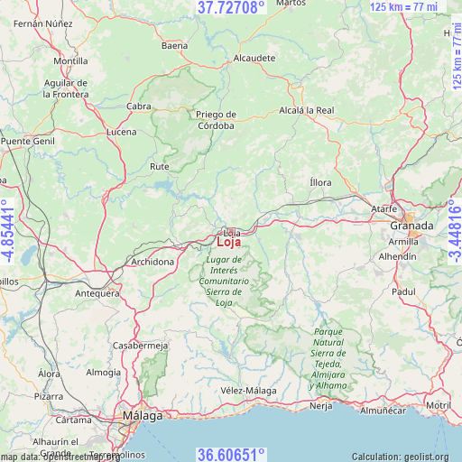
Loja GPS coordinates[2]
37° 10' 7.932" North, 4° 9' 4.644" West
| Map corner | latitude | longitude |
|---|---|---|
| Upper-left | 37.72708°, | -4.85441° |
| Center: | 37.16887°, | -4.15129° |
| Lower-right: | 36.60651°, | -3.44816° |
| Map W x H: | 124.6×124.6 km | = 77.4×77.4mi |
| max Lat: | 43.74134° ⇑94.3% North |
| Loja: | 37.16887° |
| min Lat: | ⇓5.7% South 27.64134° |
| min Long | Loja | max Long |
| -18.00367° | -4.15129° | 4.2899° |
| W 38.1%⇐ | ⇒61.9% E |
Elevation
Elevation of Loja is 453 m = 1486 ft, and this is 145 m = 476 ft below average elevation for this country.
| Max E: |
1682 m = 5518 ft | 65.5% |
| Avg. | 598 m = 1962 ft | |
| Loja | 453 m = 1486 ft | |
Min E: |
0 m = 0 ft | 34.5% |
See also: Spain elevation on elevation.city.
Geographical zone
Loja is located in North temperate zone (between Tropic of Cancer and the Arctic Circle). Distance of this Northern Tropic circle is 1526.9 km =948.8 mi to South.| Distance of | km | miles | from Loja |
|---|---|---|---|
| North Pole | 5874.3 | 3650.1 | to North |
| Arctic Circle | 3268.4 | 2030.9 | to North |
| Tropic Cancer | 1526.9 | 948.8 | to South |
| Equator | 4132.8 | 2568 | to South |


Nearby cities:
15 places around Loja: (largest is in red/bold)
• Alfarnate
21.6 km =13.4 mi,  206°
206°
• Alfarnatejo
21.6 km =13.4 mi, 206°
• Algarinejo
17.4 km =10.8 mi,  357°
357°
• Archidona
22.5 km =14 mi,  249°
249°
• Huétor-Tájar
9.8 km =6.1 mi,  70°
70°
• Iznájar
17.1 km =10.6 mi,  305°
305°
• Montefrío
21.3 km =13.2 mi,  36°
36°
• Moraleda de Zafayona
16.5 km =10.3 mi,  90°
90°
• Salar
7.9 km =4.9 mi,  105°
105°
• Venta Nueva
10.3 km =6.4 mi,  79°
79°
• Villanueva de Mesía
13.2 km =8.2 mi, 67°
• Villanueva de Tapia
16.2 km =10.1 mi,  275°
275°
• Villanueva del Trabuco
22.8 km =14.2 mi,  226°
226°
• Zafarraya
21.5 km =13.4 mi,  178°
178°
• Zagra
9.8 km =6.1 mi,  350°
350°
Sources, notices
• [Note1] Compared only with cities in Spain existing in our database
• [Src1] Map data: © OpenStreetMap contributors (CC-BY-SA)
• [Src2] Other city data from geonames.org with taken over terms of usage.
• [Src3] Geographical zone / Annual Mean Temperature by Robert A. Rohde @ Wikipedia
