Valderrubio geodata
Valderrubio (Andalusia) is a seat of a third-order administrative division; located in Spain in Europe/Madrid (GMT+2) time zone. In our database, there are 6762 cities with bigger population. Compared to other cities in Spain, 93.6% of cities are located further ↑North; 57.1% of cities are located further →East and 58.5% of cities have higher elevation than Valderrubio. Note1


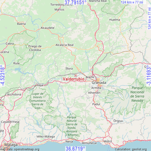
Valderrubio GPS coordinates[2]
37° 14' 1.608" North, 3° 49' 12.18" West
| Map corner | latitude | longitude |
|---|---|---|
| Upper-left | 37.79151°, | -4.52318° |
| Center: | 37.23378°, | -3.82005° |
| Lower-right: | 36.6719°, | -3.11693° |
| Map W x H: | 124.5×124.5 km | = 77.4×77.4mi |
| max Lat: | 43.74134° ⇑93.6% North |
| Valderrubio: | 37.23378° |
| min Lat: | ⇓6.4% South 27.64134° |
| min Long | Valderrubio | max Long |
| -18.00367° | -3.82005° | 4.2899° |
| W 42.9%⇐ | ⇒57.1% E |
Elevation
Elevation of Valderrubio is 548 m = 1798 ft, and this is 50 m = 164 ft below average elevation for this country.
| Max E: |
1682 m = 5518 ft | 58.5% |
| Avg. | 598 m = 1962 ft | |
| Valderrubio | 548 m = 1798 ft | |
Min E: |
0 m = 0 ft | 41.5% |
See also: Spain elevation on elevation.city.
Geographical zone
Valderrubio is located in North temperate zone (between Tropic of Cancer and the Arctic Circle). Distance of this Northern Tropic circle is 1534.1 km =953.2 mi to South.| Distance of | km | miles | from Valderrubio |
|---|---|---|---|
| North Pole | 5867.1 | 3645.6 | to North |
| Arctic Circle | 3261.2 | 2026.4 | to North |
| Tropic Cancer | 1534.1 | 953.2 | to South |
| Equator | 4140 | 2572.5 | to South |


Nearby cities:
15 places around Valderrubio: (largest is in red/bold)
• Albolote
14.6 km =9.1 mi,  91°
91°
• Atarfe
11.8 km =7.3 mi, 94°
• Chauchina
5.7 km =3.5 mi,  131°
131°
• Chimeneas
11.4 km =7.1 mi,  180°
180°
• Cijuela
4 km =2.5 mi,  169°
169°
• Cúllar-Vega
16 km =9.9 mi,  123°
123°
• Fuente Vaqueros
3.6 km =2.2 mi,  114°
114°
• Illora
8.1 km =5 mi,  317°
317°
• Láchar
4.4 km =2.7 mi,  194°
194°
• Maracena
16.6 km =10.3 mi,  100°
100°
• Moclín
12.1 km =7.5 mi,  14°
14°
• Moraleda de Zafayona
14.8 km =9.2 mi,  240°
240°
• Peligros
16.9 km =10.5 mi, 90°
• Pinos Puente
6.5 km =4 mi,  72°
72°
• Santafé
10.3 km =6.4 mi, 119°
Sources, notices
• [Note1] Compared only with cities in Spain existing in our database
• [Src1] Map data: © OpenStreetMap contributors (CC-BY-SA)
• [Src2] Other city data from geonames.org with taken over terms of usage.
• [Src3] Geographical zone / Annual Mean Temperature by Robert A. Rohde @ Wikipedia
