Chimeneas geodata
Chimeneas (Andalusia) is a seat of a third-order administrative division; located in Spain in Europe/Madrid (GMT+2) time zone. With population of 1,472 people, there are 2484 cities with bigger population in this country. Compared to other cities in Spain, 94.7% of cities are located further ↑North; 57.1% of cities are located further →East and 53.9% of cities have lower elevation than Chimeneas. Note1


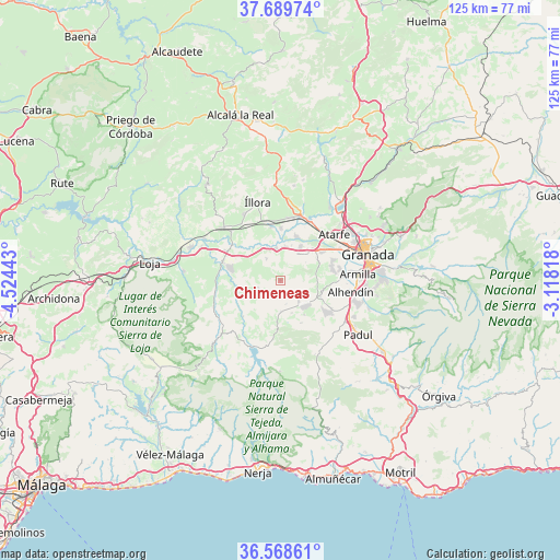
Chimeneas GPS coordinates[2]
37° 7' 52.5" North, 3° 49' 16.68" West
| Map corner | latitude | longitude |
|---|---|---|
| Upper-left | 37.68974°, | -4.52443° |
| Center: | 37.13125°, | -3.8213° |
| Lower-right: | 36.56861°, | -3.11818° |
| Map W x H: | 124.7×124.7 km | = 77.5×77.5mi |
| max Lat: | 43.74134° ⇑94.7% North |
| Chimeneas: | 37.13125° |
| min Lat: | ⇓5.3% South 27.64134° |
| min Long | Chimeneas | max Long |
| -18.00367° | -3.8213° | 4.2899° |
| W 42.9%⇐ | ⇒57.1% E |
Elevation
Elevation of Chimeneas is 699 m = 2293 ft, and this is 101 m = 331 ft above average elevation for this country.
| Max E: |
1682 m = 5518 ft | 46.1% |
| Chimeneas | 699 m 2293 ft | |
| Avg. | 598 m = 1962 ft | |
Min E: |
0 m = 0 ft | 53.9% |
See also: Spain elevation on elevation.city.
Geographical zone
Chimeneas is located in North temperate zone (between Tropic of Cancer and the Arctic Circle). Distance of this Northern Tropic circle is 1522.7 km =946.2 mi to South.| Distance of | km | miles | from Chimeneas |
|---|---|---|---|
| North Pole | 5878.5 | 3652.7 | to North |
| Arctic Circle | 3272.6 | 2033.5 | to North |
| Tropic Cancer | 1522.7 | 946.2 | to South |
| Equator | 4128.6 | 2565.4 | to South |


Nearby cities:
15 places around Chimeneas: (largest is in red/bold)
• Agrón
11.3 km =7 mi,  183°
183°
• Atarfe
15.8 km =9.8 mi,  48°
48°
• Chauchina
8.8 km =5.5 mi,  30°
30°
• Churriana de la Vega
15.6 km =9.7 mi,  84°
84°
• Cijuela
7.5 km =4.7 mi,  6°
6°
• Cúllar-Vega
13.6 km =8.5 mi, 79°
• Escúzar
9.3 km =5.8 mi,  145°
145°
• Fuente Vaqueros
10.5 km =6.5 mi,  18°
18°
• Las Gabias
13.4 km =8.3 mi,  87°
87°
• Láchar
7.2 km =4.5 mi,  351°
351°
• Moraleda de Zafayona
13.4 km =8.3 mi,  287°
287°
• Pinos Puente
14.8 km =9.2 mi, 25°
• Santafé
11.1 km =6.9 mi, 54°
• Valderrubio
11.4 km =7.1 mi,  0°
0°
• Ventas de Huelma
7 km =4.3 mi, 178°
Sources, notices
• [Note1] Compared only with cities in Spain existing in our database
• [Src1] Map data: © OpenStreetMap contributors (CC-BY-SA)
• [Src2] Other city data from geonames.org with taken over terms of usage.
• [Src3] Geographical zone / Annual Mean Temperature by Robert A. Rohde @ Wikipedia
