Salar geodata
Salar (Andalusia) is a seat of a third-order administrative division; located in Spain in Europe/Madrid (GMT+2) time zone. With population of 2,772 people, there are 1791 cities with bigger population in this country. Compared to other cities in Spain, 94.5% of cities are located further ↑North; 60.7% of cities are located further →East and 57.5% of cities have higher elevation than Salar. Note1


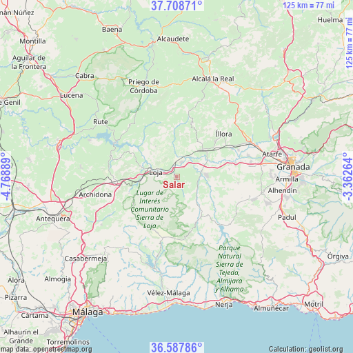
Salar GPS coordinates[2]
37° 9' 1.296" North, 4° 3' 56.736" West
| Map corner | latitude | longitude |
|---|---|---|
| Upper-left | 37.70871°, | -4.76889° |
| Center: | 37.15036°, | -4.06576° |
| Lower-right: | 36.58786°, | -3.36264° |
| Map W x H: | 124.6×124.6 km | = 77.4×77.4mi |
| max Lat: | 43.74134° ⇑94.5% North |
| Salar: | 37.15036° |
| min Lat: | ⇓5.5% South 27.64134° |
| min Long | Salar | max Long |
| -18.00367° | -4.06576° | 4.2899° |
| W 39.3%⇐ | ⇒60.7% E |
Elevation
Elevation of Salar is 557 m = 1827 ft, and this is 41 m = 135 ft below average elevation for this country.
| Max E: |
1682 m = 5518 ft | 57.5% |
| Avg. | 598 m = 1962 ft | |
| Salar | 557 m = 1827 ft | |
Min E: |
0 m = 0 ft | 42.5% |
See also: Spain elevation on elevation.city.
Geographical zone
Salar is located in North temperate zone (between Tropic of Cancer and the Arctic Circle). Distance of this Northern Tropic circle is 1524.8 km =947.5 mi to South.| Distance of | km | miles | from Salar |
|---|---|---|---|
| North Pole | 5876.3 | 3651.4 | to North |
| Arctic Circle | 3270.4 | 2032.1 | to North |
| Tropic Cancer | 1524.8 | 947.5 | to South |
| Equator | 4130.7 | 2566.7 | to South |


Nearby cities:
15 places around Salar: (largest is in red/bold)
• Algarinejo
21.1 km =13.1 mi,  337°
337°
• Alhama de Granada
17.3 km =10.7 mi,  157°
157°
• Chimeneas
21.8 km =13.5 mi,  95°
95°
• Cijuela
23.1 km =14.4 mi,  76°
76°
• Huétor-Tájar
5.6 km =3.5 mi,  17°
17°
• Illora
22.4 km =13.9 mi,  46°
46°
• Loja
7.9 km =4.9 mi,  285°
285°
• Láchar
21.2 km =13.2 mi, 76°
• Montefrío
19.9 km =12.4 mi,  14°
14°
• Moraleda de Zafayona
9.1 km =5.7 mi, 78°
• Venta Nueva
4.7 km =2.9 mi,  32°
32°
• Ventas de Huelma
23.6 km =14.7 mi,  112°
112°
• Villanueva de Mesía
8.5 km =5.3 mi, 32°
• Zafarraya
20.7 km =12.9 mi,  199°
199°
• Zagra
14.9 km =9.3 mi,  321°
321°
Sources, notices
• [Note1] Compared only with cities in Spain existing in our database
• [Src1] Map data: © OpenStreetMap contributors (CC-BY-SA)
• [Src2] Other city data from geonames.org with taken over terms of usage.
• [Src3] Geographical zone / Annual Mean Temperature by Robert A. Rohde @ Wikipedia
