Villamuelas geodata
Villamuelas (Castille-La Mancha) is a seat of a third-order administrative division; located in Spain in Europe/Madrid (GMT+2) time zone. With population of 729 people, there are 3348 cities with bigger population in this country. Compared to other cities in Spain, 72.7% of cities are located further ↑North; 55.8% of cities are located further →East and 55.3% of cities have higher elevation than Villamuelas. Note1
Administrative division(s):
- Level 1: Castille-La Mancha
- Level 2: Province of Toledo
- Level 3: Villamuelas


Villamuelas GPS coordinates[2]
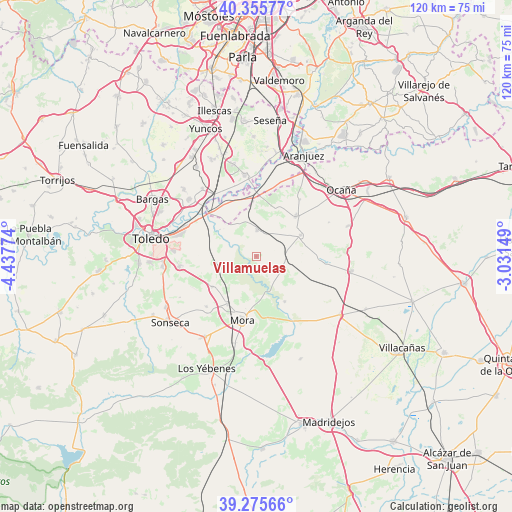
39° 49' 4.224" North, 3° 44' 4.596" West
| Map corner | latitude | longitude |
|---|---|---|
| Upper-left | 40.35577°, | -4.43774° |
| Center: | 39.81784°, | -3.73461° |
| Lower-right: | 39.27566°, | -3.03149° |
| Map W x H: | 120.1×120.1 km | = 74.6×74.6mi |
| max Lat: | 43.74134° ⇑72.7% North |
| Villamuelas: | 39.81784° |
| min Lat: | ⇓27.3% South 27.64134° |
| min Long | Villamuelas | max Long |
| -18.00367° | -3.73461° | 4.2899° |
| W 44.2%⇐ | ⇒55.8% E |
Elevation
Elevation of Villamuelas is 591 m = 1939 ft, and this is 7 m = 23 ft below average elevation for this country.
| Max E: |
1682 m = 5518 ft | 55.3% |
| Avg. | 598 m = 1962 ft | |
| Villamuelas | 591 m = 1939 ft | |
Min E: |
0 m = 0 ft | 44.7% |
See also: Spain elevation on elevation.city.
Geographical zone
Villamuelas is located in North temperate zone (between Tropic of Cancer and the Arctic Circle). Distance of this Northern Tropic circle is 1821.4 km =1131.8 mi to South.| Distance of | km | miles | from Villamuelas |
|---|---|---|---|
| North Pole | 5579.7 | 3467.1 | to North |
| Arctic Circle | 2973.8 | 1847.8 | to North |
| Tropic Cancer | 1821.4 | 1131.8 | to South |
| Equator | 4427.3 | 2751 | to South |


Nearby cities:
15 places around Villamuelas: (largest is in red/bold)
• Almonacid de Toledo
12.3 km =7.6 mi,  234°
234°
• Añover de Tajo
19.2 km =11.9 mi,  352°
352°
• Cabañas de Yepes
18.9 km =11.7 mi,  64°
64°
• Chueca
20.3 km =12.6 mi,  241°
241°
• Ciruelos
16.9 km =10.5 mi,  37°
37°
• Huerta de Valdecarábanos
11.6 km =7.2 mi, 64°
• Mascaraque
13.1 km =8.1 mi,  210°
210°
• Mocejón
20.6 km =12.8 mi,  310°
310°
• Mora
15.2 km =9.4 mi,  192°
192°
• Nambroca
18.1 km =11.2 mi,  262°
262°
• Villaminaya
16.5 km =10.3 mi,  224°
224°
• Villanueva de Bogas
12.4 km =7.7 mi,  147°
147°
• Villaseca de la Sagra
20.4 km =12.7 mi,  321°
321°
• Villasequilla de Yepes
6.5 km =4 mi,  2°
2°
• Yepes
13.2 km =8.2 mi, 44°
Sources, notices
• [Note1] Compared only with cities in Spain existing in our database
• [Src1] Map data: © OpenStreetMap contributors (CC-BY-SA)
• [Src2] Other city data from geonames.org with taken over terms of usage.
• [Src3] Geographical zone / Annual Mean Temperature by Robert A. Rohde @ Wikipedia
