Ciruelos geodata
Ciruelos (Castille-La Mancha) is a seat of a third-order administrative division; located in Spain in Europe/Madrid (GMT+2) time zone. With population of 412 people, there are 4106 cities with bigger population in this country. Compared to other cities in Spain, 71.1% of cities are located further ↑North; 53.9% of cities are located further →East and 54.6% of cities have lower elevation than Ciruelos. Note1
Administrative division(s):
- Level 1: Castille-La Mancha
- Level 2: Province of Toledo
- Level 3: Ciruelos


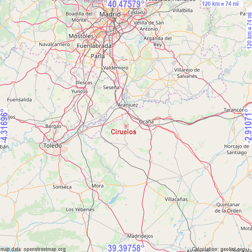
Ciruelos GPS coordinates[2]
39° 56' 19.716" North, 3° 36' 49.788" West
| Map corner | latitude | longitude |
|---|---|---|
| Upper-left | 40.47579°, | -4.31696° |
| Center: | 39.93881°, | -3.61383° |
| Lower-right: | 39.39758°, | -2.91071° |
| Map W x H: | 119.9×119.9 km | = 74.5×74.5mi |
| max Lat: | 43.74134° ⇑71.1% North |
| Ciruelos: | 39.93881° |
| min Lat: | ⇓28.9% South 27.64134° |
| min Long | Ciruelos | max Long |
| -18.00367° | -3.61383° | 4.2899° |
| W 46.1%⇐ | ⇒53.9% E |
Elevation
Elevation of Ciruelos is 706 m = 2316 ft, and this is 108 m = 354 ft above average elevation for this country.
| Max E: |
1682 m = 5518 ft | 45.4% |
| Ciruelos | 706 m 2316 ft | |
| Avg. | 598 m = 1962 ft | |
Min E: |
0 m = 0 ft | 54.6% |
See also: Spain elevation on elevation.city.
Geographical zone
Ciruelos is located in North temperate zone (between Tropic of Cancer and the Arctic Circle). Distance of this Northern Tropic circle is 1834.9 km =1140.2 mi to South.| Distance of | km | miles | from Ciruelos |
|---|---|---|---|
| North Pole | 5566.3 | 3458.7 | to North |
| Arctic Circle | 2960.4 | 1839.5 | to North |
| Tropic Cancer | 1834.9 | 1140.2 | to South |
| Equator | 4440.8 | 2759.4 | to South |


Nearby cities:
15 places around Ciruelos: (largest is in red/bold)
• Aranjuez
10.3 km =6.4 mi,  5°
5°
• Añover de Tajo
14.1 km =8.8 mi,  293°
293°
• Borox
17.8 km =11.1 mi,  323°
323°
• Cabañas de Yepes
8.6 km =5.3 mi,  128°
128°
• Dosbarrios
12.7 km =7.9 mi,  119°
119°
• Huerta de Valdecarábanos
8.4 km =5.2 mi,  179°
179°
• La Alameda de la Sagra
17.3 km =10.7 mi,  298°
298°
• La Guardia
20.5 km =12.7 mi,  144°
144°
• Noblejas
15.5 km =9.6 mi,  72°
72°
• Ocaña
10.1 km =6.3 mi,  77°
77°
• Ontígola
8.1 km =5 mi,  25°
25°
• Seseña
19.8 km =12.3 mi,  338°
338°
• Villamuelas
16.9 km =10.5 mi,  217°
217°
• Villasequilla de Yepes
12.2 km =7.6 mi,  234°
234°
• Yepes
4.2 km =2.6 mi,  193°
193°
Sources, notices
• [Note1] Compared only with cities in Spain existing in our database
• [Src1] Map data: © OpenStreetMap contributors (CC-BY-SA)
• [Src2] Other city data from geonames.org with taken over terms of usage.
• [Src3] Geographical zone / Annual Mean Temperature by Robert A. Rohde @ Wikipedia
