La Guardia geodata
La Guardia (Castille-La Mancha) is a populated place; located in Spain in Europe/Madrid (GMT+2) time zone. With population of 2,329 people, there are 1985 cities with bigger population in this country. Compared to other cities in Spain, 73% of cities are located further ↑North; 51.7% of cities are located further →East and 54.4% of cities have lower elevation than La Guardia. Note1
Administrative division(s):
- Level 1: Castille-La Mancha
- Level 2: Province of Toledo
- Level 3: Guardia, La


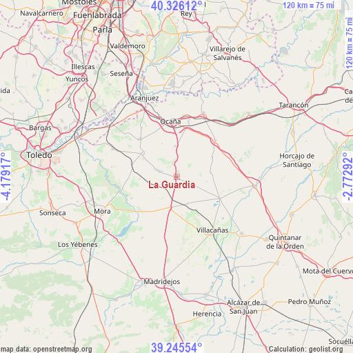
La Guardia GPS coordinates[2]
39° 47' 16.62" North, 3° 28' 33.744" West
| Map corner | latitude | longitude |
|---|---|---|
| Upper-left | 40.32612°, | -4.17917° |
| Center: | 39.78795°, | -3.47604° |
| Lower-right: | 39.24554°, | -2.77292° |
| Map W x H: | 120.1×120.1 km | = 74.6×74.6mi |
| max Lat: | 43.74134° ⇑73% North |
| La Guardia: | 39.78795° |
| min Lat: | ⇓27% South 27.64134° |
| min Long | La Guardia | max Long |
| -18.00367° | -3.47604° | 4.2899° |
| W 48.3%⇐ | ⇒51.7% E |
Elevation
Elevation of La Guardia is 704 m = 2310 ft, and this is 106 m = 348 ft above average elevation for this country.
| Max E: |
1682 m = 5518 ft | 45.6% |
| La Guardia | 704 m 2310 ft | |
| Avg. | 598 m = 1962 ft | |
Min E: |
0 m = 0 ft | 54.4% |
See also: Spain elevation on elevation.city.
Geographical zone
La Guardia is located in North temperate zone (between Tropic of Cancer and the Arctic Circle). Distance of this Northern Tropic circle is 1818.1 km =1129.7 mi to South.| Distance of | km | miles | from La Guardia |
|---|---|---|---|
| North Pole | 5583.1 | 3469.2 | to North |
| Arctic Circle | 2977.2 | 1849.9 | to North |
| Tropic Cancer | 1818.1 | 1129.7 | to South |
| Equator | 4424 | 2748.9 | to South |


Nearby cities:
15 places around La Guardia: (largest is in red/bold)
• Cabañas de Yepes
12.5 km =7.8 mi,  336°
336°
• Ciruelos
20.5 km =12.7 mi,  324°
324°
• Dosbarrios
10.5 km =6.5 mi,  356°
356°
• Huerta de Valdecarábanos
14.4 km =8.9 mi,  305°
305°
• Lillo
16.2 km =10.1 mi,  116°
116°
• Noblejas
21.6 km =13.4 mi,  8°
8°
• Ocaña
19 km =11.8 mi,  354°
354°
• Romeral
9.7 km =6 mi,  158°
158°
• Tembleque
10.6 km =6.6 mi,  193°
193°
• Villacañas
21.7 km =13.5 mi,  147°
147°
• Villamuelas
22.3 km =13.9 mi,  278°
278°
• Villanueva de Bogas
17.1 km =10.6 mi,  245°
245°
• Villarrubia de Santiago
23.8 km =14.8 mi,  22°
22°
• Villatobas
18.1 km =11.2 mi,  45°
45°
• Yepes
18 km =11.2 mi, 314°
Sources, notices
• [Note1] Compared only with cities in Spain existing in our database
• [Src1] Map data: © OpenStreetMap contributors (CC-BY-SA)
• [Src2] Other city data from geonames.org with taken over terms of usage.
• [Src3] Geographical zone / Annual Mean Temperature by Robert A. Rohde @ Wikipedia
