Tembleque geodata
Tembleque (Castille-La Mancha) is a seat of a third-order administrative division; located in Spain in Europe/Madrid (GMT+2) time zone. With population of 2,202 people, there are 2046 cities with bigger population in this country. Compared to other cities in Spain, 74.5% of cities are located further ↑North; 52.2% of cities are located further →East and 51.8% of cities have higher elevation than Tembleque. Note1
Administrative division(s):
- Level 1: Castille-La Mancha
- Level 2: Province of Toledo
- Level 3: Tembleque


Tembleque GPS coordinates[2]
39° 41' 43.476" North, 3° 30' 15.444" West
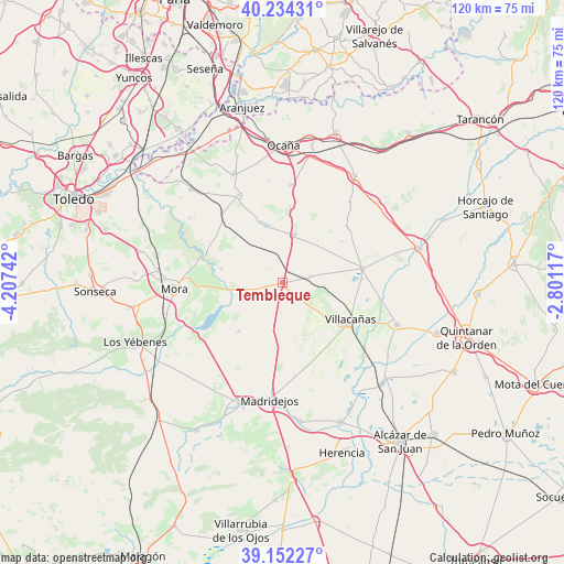
| Map corner | latitude | longitude |
|---|---|---|
| Upper-left | 40.23431°, | -4.20742° |
| Center: | 39.69541°, | -3.50429° |
| Lower-right: | 39.15227°, | -2.80117° |
| Map W x H: | 120.3×120.3 km | = 74.8×74.8mi |
| max Lat: | 43.74134° ⇑74.5% North |
| Tembleque: | 39.69541° |
| min Lat: | ⇓25.5% South 27.64134° |
| min Long | Tembleque | max Long |
| -18.00367° | -3.50429° | 4.2899° |
| W 47.8%⇐ | ⇒52.2% E |
Elevation
Elevation of Tembleque is 640 m = 2100 ft, and this is 42 m = 138 ft above average elevation for this country.
| Max E: |
1682 m = 5518 ft | 51.8% |
| Tembleque | 640 m 2100 ft | |
| Avg. | 598 m = 1962 ft | |
Min E: |
0 m = 0 ft | 48.2% |
See also: Spain elevation on elevation.city.
Geographical zone
Tembleque is located in North temperate zone (between Tropic of Cancer and the Arctic Circle). Distance of this Northern Tropic circle is 1807.8 km =1123.3 mi to South.| Distance of | km | miles | from Tembleque |
|---|---|---|---|
| North Pole | 5593.3 | 3475.5 | to North |
| Arctic Circle | 2987.5 | 1856.3 | to North |
| Tropic Cancer | 1807.8 | 1123.3 | to South |
| Equator | 4413.7 | 2742.5 | to South |


Nearby cities:
15 places around Tembleque: (largest is in red/bold)
• Cabañas de Yepes
21.9 km =13.6 mi,  353°
353°
• Dosbarrios
20.8 km =12.9 mi,  4°
4°
• Huerta de Valdecarábanos
20.8 km =12.9 mi,  333°
333°
• La Guardia
10.6 km =6.6 mi,  13°
13°
• Lillo
17.2 km =10.7 mi,  79°
79°
• Madridejos
25.4 km =15.8 mi,  185°
185°
• Manzaneque
25.6 km =15.9 mi,  254°
254°
• Mora
23.1 km =14.4 mi,  267°
267°
• Romeral
6.2 km =3.9 mi, 77°
• Turleque
14.1 km =8.8 mi,  221°
221°
• Villa de Don Fadrique
26 km =16.2 mi,  110°
110°
• Villacañas
16.3 km =10.1 mi,  119°
119°
• Villamuelas
23.9 km =14.9 mi,  304°
304°
• Villanueva de Bogas
13.5 km =8.4 mi,  283°
283°
• Yepes
25.2 km =15.7 mi,  335°
335°
Sources, notices
• [Note1] Compared only with cities in Spain existing in our database
• [Src1] Map data: © OpenStreetMap contributors (CC-BY-SA)
• [Src2] Other city data from geonames.org with taken over terms of usage.
• [Src3] Geographical zone / Annual Mean Temperature by Robert A. Rohde @ Wikipedia
