Vallehermosa geodata
Vallehermosa (Canary Islands) is a populated place; located in Spain in Atlantic/Canary (GMT+1) time zone. With population of 3,303 people, there are 1634 cities with bigger population in this country. Compared to other cities in Spain, 99.4% of cities are located further ↑North; 99.7% of cities are located further →East and 82% of cities have higher elevation than Vallehermosa. Note1
Administrative division(s):
- Level 1: Canary Islands
- Level 2: Provincia de Santa Cruz de Tenerife
- Level 3: Vallehermoso


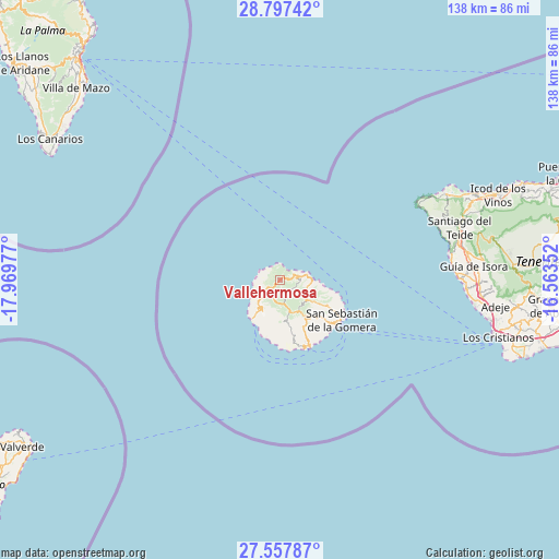
Vallehermosa GPS coordinates[2]
28° 10' 45.984" North, 17° 15' 59.904" West
| Map corner | latitude | longitude |
|---|---|---|
| Upper-left | 28.79742°, | -17.96977° |
| Center: | 28.17944°, | -17.26664° |
| Lower-right: | 27.55787°, | -16.56352° |
| Map W x H: | 137.8×137.8 km | = 85.6×85.6mi |
| max Lat: | 43.74134° ⇑99.4% North |
| Vallehermosa: | 28.17944° |
| min Lat: | ⇓0.6% South 27.64134° |
| min Long | Vallehermosa | max Long |
| -18.00367° | -17.26664° | 4.2899° |
| W 0.3%⇐ | ⇒99.7% E |
Elevation
Elevation of Vallehermosa is 187 m = 614 ft, and this is 411 m = 1348 ft below average elevation for this country.
| Max E: |
1682 m = 5518 ft | 82% |
| Avg. | 598 m = 1962 ft | |
| Vallehermosa | 187 m = 614 ft | |
Min E: |
0 m = 0 ft | 18% |
See also: Spain elevation on elevation.city.
Geographical zone
Vallehermosa is located in North temperate zone (between Tropic of Cancer and the Arctic Circle). Distance of this Northern Tropic circle is 527.3 km =327.6 mi to South.| Distance of | km | miles | from Vallehermosa |
|---|---|---|---|
| North Pole | 6873.8 | 4271.2 | to North |
| Arctic Circle | 4267.9 | 2651.9 | to North |
| Tropic Cancer | 527.3 | 327.6 | to South |
| Equator | 3133.3 | 1946.9 | to South |


Nearby cities:
15 places around Vallehermosa: (largest is in red/bold)
• Adeje
53.4 km =33.2 mi,  96°
96°
• Agulo
6.9 km =4.3 mi,  82°
82°
• Alajeró
13.3 km =8.3 mi,  168°
168°
• Buenavista del Norte
45.3 km =28.1 mi,  61°
61°
• Garachico
53.8 km =33.4 mi,  66°
66°
• Guía de Isora
47.9 km =29.8 mi,  85°
85°
• Hermigua
7.6 km =4.7 mi, 99°
• Los Gigantes
42.3 km =26.3 mi, 80°
• Los Silos
48.8 km =30.3 mi, 64°
• Playa de Santiago
17.9 km =11.1 mi,  158°
158°
• Playa de las Américas
54.2 km =33.7 mi, 103°
• Puerto de Santiago
42 km =26.1 mi, 81°
• San Sebastián de la Gomera
17.9 km =11.1 mi,  123°
123°
• Santiago del Teide
45.9 km =28.5 mi, 73°
• Tanque
47.3 km =29.4 mi, 63°
In other languages:
- In Spanish: Vallehermoso
- In France: Vallehermoso
- In German: Vallehermoso
- In Italian: Vallehermoso
Sources, notices
• [Note1] Compared only with cities in Spain existing in our database
• [Src1] Map data: © OpenStreetMap contributors (CC-BY-SA)
• [Src2] Other city data from geonames.org with taken over terms of usage.
• [Src3] Geographical zone / Annual Mean Temperature by Robert A. Rohde @ Wikipedia
