Hermigua geodata
Hermigua (Canary Islands) is a seat of a third-order administrative division; located in Spain in Atlantic/Canary (GMT+1) time zone. With population of 2,195 people, there are 2052 cities with bigger population in this country. Compared to other cities in Spain, 99.4% of cities are located further ↑North; 99.7% of cities are located further →East and 87.2% of cities have higher elevation than Hermigua. Note1
Administrative division(s):
- Level 1: Canary Islands
- Level 2: Provincia de Santa Cruz de Tenerife
- Level 3: Hermigua


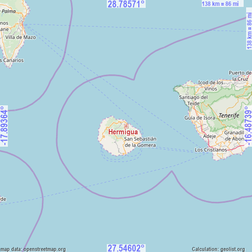
Hermigua GPS coordinates[2]
28° 10' 3.576" North, 17° 11' 25.836" West
| Map corner | latitude | longitude |
|---|---|---|
| Upper-left | 28.78571°, | -17.89364° |
| Center: | 28.16766°, | -17.19051° |
| Lower-right: | 27.54602°, | -16.48739° |
| Map W x H: | 137.8×137.8 km | = 85.6×85.6mi |
| max Lat: | 43.74134° ⇑99.4% North |
| Hermigua: | 28.16766° |
| min Lat: | ⇓0.6% South 27.64134° |
| min Long | Hermigua | max Long |
| -18.00367° | -17.19051° | 4.2899° |
| W 0.3%⇐ | ⇒99.7% E |
Elevation
Elevation of Hermigua is 107 m = 351 ft, and this is 491 m = 1611 ft below average elevation for this country.
| Max E: |
1682 m = 5518 ft | 87.2% |
| Avg. | 598 m = 1962 ft | |
| Hermigua | 107 m = 351 ft | |
Min E: |
0 m = 0 ft | 12.8% |
See also: Spain elevation on elevation.city.
Geographical zone
Hermigua is located in North temperate zone (between Tropic of Cancer and the Arctic Circle). Distance of this Northern Tropic circle is 526 km =326.8 mi to South.| Distance of | km | miles | from Hermigua |
|---|---|---|---|
| North Pole | 6875.1 | 4272 | to North |
| Arctic Circle | 4269.2 | 2652.8 | to North |
| Tropic Cancer | 526 | 326.8 | to South |
| Equator | 3132 | 1946.1 | to South |


Nearby cities:
15 places around Hermigua: (largest is in red/bold)
• Adeje
45.8 km =28.5 mi,  96°
96°
• Agulo
2.3 km =1.4 mi,  344°
344°
• Alajeró
12.7 km =7.9 mi,  202°
202°
• Buenavista del Norte
39.6 km =24.6 mi,  54°
54°
• Garachico
47.7 km =29.6 mi,  61°
61°
• Guía de Isora
40.6 km =25.2 mi,  83°
83°
• Los Gigantes
35.2 km =21.9 mi, 76°
• Los Silos
42.8 km =26.6 mi, 59°
• Playa de Santiago
15.3 km =9.5 mi,  182°
182°
• Playa de las Américas
46.6 km =29 mi, 104°
• Puerto de Santiago
34.9 km =21.7 mi, 77°
• San Sebastián de la Gomera
11.3 km =7 mi,  138°
138°
• Santiago del Teide
39.3 km =24.4 mi,  69°
69°
• Tanque
41.4 km =25.7 mi, 57°
• Vallehermosa
7.6 km =4.7 mi,  279°
279°
Sources, notices
• [Note1] Compared only with cities in Spain existing in our database
• [Src1] Map data: © OpenStreetMap contributors (CC-BY-SA)
• [Src2] Other city data from geonames.org with taken over terms of usage.
• [Src3] Geographical zone / Annual Mean Temperature by Robert A. Rohde @ Wikipedia
