Alajeró geodata
Alajeró (Canary Islands) is a populated place; located in Spain in Atlantic/Canary (GMT+1) time zone. With population of 2,066 people, there are 2122 cities with bigger population in this country. Compared to other cities in Spain, 99.6% of cities are located further ↑North; 99.7% of cities are located further →East and 68.8% of cities have lower elevation than Alajeró. Note1
Administrative division(s):
- Level 1: Canary Islands
- Level 2: Provincia de Santa Cruz de Tenerife
- Level 3: Alajeró


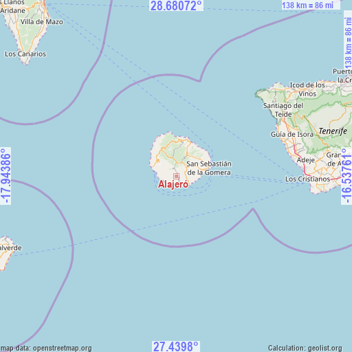
Alajeró GPS coordinates[2]
28° 3' 43.38" North, 17° 14' 26.628" West
| Map corner | latitude | longitude |
|---|---|---|
| Upper-left | 28.68072°, | -17.94386° |
| Center: | 28.06205°, | -17.24073° |
| Lower-right: | 27.4398°, | -16.53761° |
| Map W x H: | 138×138 km | = 85.7×85.7mi |
| max Lat: | 43.74134° ⇑99.6% North |
| Alajeró: | 28.06205° |
| min Lat: | ⇓0.4% South 27.64134° |
| min Long | Alajeró | max Long |
| -18.00367° | -17.24073° | 4.2899° |
| W 0.3%⇐ | ⇒99.7% E |
Elevation
Elevation of Alajeró is 804 m = 2638 ft, and this is 206 m = 676 ft above average elevation for this country.
| Max E: |
1682 m = 5518 ft | 31.2% |
| Alajeró | 804 m 2638 ft | |
| Avg. | 598 m = 1962 ft | |
Min E: |
0 m = 0 ft | 68.8% |
See also: Spain elevation on elevation.city.
Geographical zone
Alajeró is located in North temperate zone (between Tropic of Cancer and the Arctic Circle). Distance of this Northern Tropic circle is 514.3 km =319.6 mi to South.| Distance of | km | miles | from Alajeró |
|---|---|---|---|
| North Pole | 6886.9 | 4279.3 | to North |
| Arctic Circle | 4281 | 2660.1 | to North |
| Tropic Cancer | 514.3 | 319.6 | to South |
| Equator | 3120.2 | 1938.8 | to South |


Nearby cities:
15 places around Alajeró: (largest is in red/bold)
• Adeje
50.9 km =31.6 mi,  82°
82°
• Agulo
14.6 km =9.1 mi,  17°
17°
• Arona
55.1 km =34.2 mi,  85°
85°
• Buenavista del Norte
50.9 km =31.6 mi,  46°
46°
• Guía de Isora
48.2 km =30 mi,  69°
69°
• Hermigua
12.7 km =7.9 mi, 22°
• Los Gigantes
44 km =27.3 mi,  62°
62°
• Los Silos
53.7 km =33.4 mi, 50°
• Playa de Santiago
5.5 km =3.4 mi,  130°
130°
• Playa de las Américas
50.1 km =31.1 mi, 89°
• Puerto de Santiago
43.5 km =27 mi, 63°
• San Sebastián de la Gomera
12.9 km =8 mi, 75°
• Santiago del Teide
49 km =30.4 mi, 58°
• Tanque
52.4 km =32.6 mi, 49°
• Vallehermosa
13.3 km =8.3 mi,  348°
348°
Sources, notices
• [Note1] Compared only with cities in Spain existing in our database
• [Src1] Map data: © OpenStreetMap contributors (CC-BY-SA)
• [Src2] Other city data from geonames.org with taken over terms of usage.
• [Src3] Geographical zone / Annual Mean Temperature by Robert A. Rohde @ Wikipedia
