Valdetorres geodata
Valdetorres (Extremadura) is a seat of a third-order administrative division; located in Spain in Europe/Madrid (GMT+2) time zone. With population of 1,301 people, there are 2644 cities with bigger population in this country. Compared to other cities in Spain, 82% of cities are located further ↑North; 86.9% of cities are located further →East and 78.7% of cities have higher elevation than Valdetorres. Note1


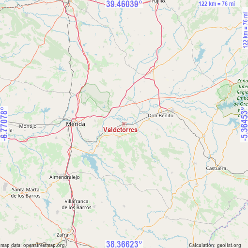
Valdetorres GPS coordinates[2]
38° 54' 55.512" North, 6° 4' 3.54" West
| Map corner | latitude | longitude |
|---|---|---|
| Upper-left | 39.46039°, | -6.77078° |
| Center: | 38.91542°, | -6.06765° |
| Lower-right: | 38.36623°, | -5.36453° |
| Map W x H: | 121.7×121.7 km | = 75.6×75.6mi |
| max Lat: | 43.74134° ⇑82% North |
| Valdetorres: | 38.91542° |
| min Lat: | ⇓18% South 27.64134° |
| min Long | Valdetorres | max Long |
| -18.00367° | -6.06765° | 4.2899° |
| W 13.1%⇐ | ⇒86.9% E |
Elevation
Elevation of Valdetorres is 243 m = 797 ft, and this is 355 m = 1165 ft below average elevation for this country.
| Max E: |
1682 m = 5518 ft | 78.7% |
| Avg. | 598 m = 1962 ft | |
| Valdetorres | 243 m = 797 ft | |
Min E: |
0 m = 0 ft | 21.3% |
See also: Spain elevation on elevation.city.
Geographical zone
Valdetorres is located in North temperate zone (between Tropic of Cancer and the Arctic Circle). Distance of this Northern Tropic circle is 1721.1 km =1069.4 mi to South.| Distance of | km | miles | from Valdetorres |
|---|---|---|---|
| North Pole | 5680.1 | 3529.4 | to North |
| Arctic Circle | 3074.2 | 1910.2 | to North |
| Tropic Cancer | 1721.1 | 1069.4 | to South |
| Equator | 4327 | 2688.7 | to South |


Nearby cities:
15 places around Valdetorres: (largest is in red/bold)
• Alange
21.2 km =13.2 mi,  226°
226°
• Cristina
9.1 km =5.7 mi,  197°
197°
• Don Benito
18.4 km =11.4 mi,  75°
75°
• Don Álvaro
19.4 km =12.1 mi,  247°
247°
• Guareña
6.8 km =4.2 mi, 204°
• Manchita
12 km =7.5 mi,  160°
160°
• Medellín
10.9 km =6.8 mi,  61°
61°
• Mengabril
11.8 km =7.3 mi, 79°
• Oliva de Mérida
14.7 km =9.1 mi, 199°
• San Pedro de Mérida
11 km =6.8 mi,  290°
290°
• Santa Amalia
11.7 km =7.3 mi,  24°
24°
• Trujillanos
16.9 km =10.5 mi,  284°
284°
• Valverde de Mérida
13.2 km =8.2 mi,  267°
267°
• Villagonzalo
12.6 km =7.8 mi,  242°
242°
• Zarza de Alange
16.9 km =10.5 mi, 230°
Sources, notices
• [Note1] Compared only with cities in Spain existing in our database
• [Src1] Map data: © OpenStreetMap contributors (CC-BY-SA)
• [Src2] Other city data from geonames.org with taken over terms of usage.
• [Src3] Geographical zone / Annual Mean Temperature by Robert A. Rohde @ Wikipedia
