Cristina geodata
Cristina (Extremadura) is a seat of a third-order administrative division; located in Spain in Europe/Madrid (GMT+2) time zone. With population of 568 people, there are 3684 cities with bigger population in this country. Compared to other cities in Spain, 82.9% of cities are located further ↑North; 87.3% of cities are located further →East and 75% of cities have higher elevation than Cristina. Note1


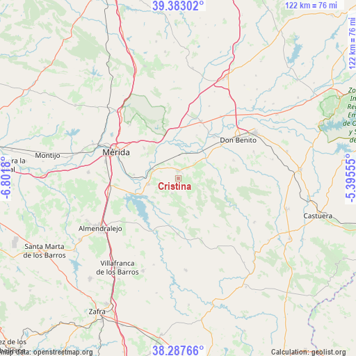
Cristina GPS coordinates[2]
38° 50' 14.82" North, 6° 5' 55.212" West
| Map corner | latitude | longitude |
|---|---|---|
| Upper-left | 39.38302°, | -6.8018° |
| Center: | 38.83745°, | -6.09867° |
| Lower-right: | 38.28766°, | -5.39555° |
| Map W x H: | 121.8×121.8 km | = 75.7×75.7mi |
| max Lat: | 43.74134° ⇑82.9% North |
| Cristina: | 38.83745° |
| min Lat: | ⇓17.1% South 27.64134° |
| min Long | Cristina | max Long |
| -18.00367° | -6.09867° | 4.2899° |
| W 12.7%⇐ | ⇒87.3% E |
Elevation
Elevation of Cristina is 296 m = 971 ft, and this is 302 m = 991 ft below average elevation for this country.
| Max E: |
1682 m = 5518 ft | 75% |
| Avg. | 598 m = 1962 ft | |
| Cristina | 296 m = 971 ft | |
Min E: |
0 m = 0 ft | 25% |
See also: Spain elevation on elevation.city.
Geographical zone
Cristina is located in North temperate zone (between Tropic of Cancer and the Arctic Circle). Distance of this Northern Tropic circle is 1712.4 km =1064 mi to South.| Distance of | km | miles | from Cristina |
|---|---|---|---|
| North Pole | 5688.7 | 3534.8 | to North |
| Arctic Circle | 3082.9 | 1915.6 | to North |
| Tropic Cancer | 1712.4 | 1064 | to South |
| Equator | 4318.3 | 2683.3 | to South |


Nearby cities:
15 places around Cristina: (largest is in red/bold)
• Alange
14 km =8.7 mi,  245°
245°
• Don Álvaro
15.3 km =9.5 mi,  274°
274°
• Guareña
2.5 km =1.6 mi,  357°
357°
• Manchita
7.3 km =4.5 mi,  111°
111°
• Medellín
18.5 km =11.5 mi,  41°
41°
• Mengabril
18 km =11.2 mi,  52°
52°
• Oliva de Mérida
5.7 km =3.5 mi,  202°
202°
• Palomas
16.4 km =10.2 mi,  191°
191°
• Puebla de la Reina
19.2 km =11.9 mi,  180°
180°
• San Pedro de Mérida
14.6 km =9.1 mi,  328°
328°
• Trujillanos
18.8 km =11.7 mi,  312°
312°
• Valdetorres
9.1 km =5.7 mi,  17°
17°
• Valverde de Mérida
13.3 km =8.3 mi, 307°
• Villagonzalo
9 km =5.6 mi,  288°
288°
• Zarza de Alange
10.5 km =6.5 mi,  258°
258°
Sources, notices
• [Note1] Compared only with cities in Spain existing in our database
• [Src1] Map data: © OpenStreetMap contributors (CC-BY-SA)
• [Src2] Other city data from geonames.org with taken over terms of usage.
• [Src3] Geographical zone / Annual Mean Temperature by Robert A. Rohde @ Wikipedia
