Trujillanos geodata
Trujillanos (Extremadura) is a seat of a third-order administrative division; located in Spain in Europe/Madrid (GMT+2) time zone. With population of 1,347 people, there are 2598 cities with bigger population in this country. Compared to other cities in Spain, 81.4% of cities are located further ↑North; 89% of cities are located further →East and 78.1% of cities have higher elevation than Trujillanos. Note1


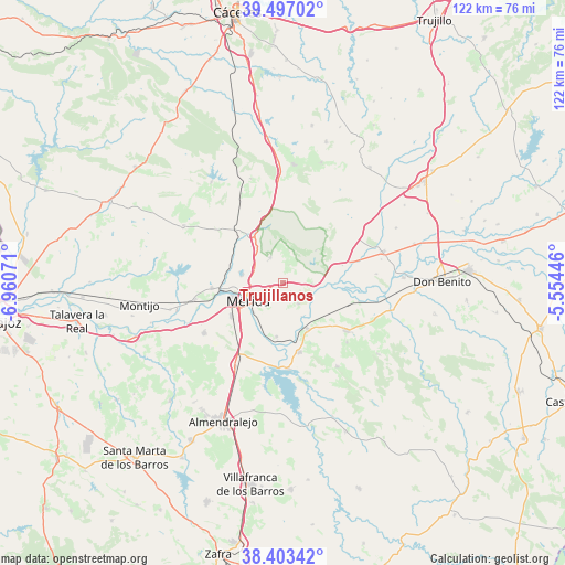
Trujillanos GPS coordinates[2]
38° 57' 8.388" North, 6° 15' 27.324" West
| Map corner | latitude | longitude |
|---|---|---|
| Upper-left | 39.49702°, | -6.96071° |
| Center: | 38.95233°, | -6.25759° |
| Lower-right: | 38.40342°, | -5.55446° |
| Map W x H: | 121.6×121.6 km | = 75.6×75.6mi |
| max Lat: | 43.74134° ⇑81.4% North |
| Trujillanos: | 38.95233° |
| min Lat: | ⇓18.6% South 27.64134° |
| min Long | Trujillanos | max Long |
| -18.00367° | -6.25759° | 4.2899° |
| W 11%⇐ | ⇒89% E |
Elevation
Elevation of Trujillanos is 255 m = 837 ft, and this is 343 m = 1125 ft below average elevation for this country.
| Max E: |
1682 m = 5518 ft | 78.1% |
| Avg. | 598 m = 1962 ft | |
| Trujillanos | 255 m = 837 ft | |
Min E: |
0 m = 0 ft | 21.9% |
See also: Spain elevation on elevation.city.
Geographical zone
Trujillanos is located in North temperate zone (between Tropic of Cancer and the Arctic Circle). Distance of this Northern Tropic circle is 1725.2 km =1072 mi to South.| Distance of | km | miles | from Trujillanos |
|---|---|---|---|
| North Pole | 5676 | 3526.9 | to North |
| Arctic Circle | 3070.1 | 1907.7 | to North |
| Tropic Cancer | 1725.2 | 1072 | to South |
| Equator | 4331.1 | 2691.2 | to South |


Nearby cities:
15 places around Trujillanos: (largest is in red/bold)
• Alange
18.6 km =11.6 mi,  176°
176°
• Aljucén
12 km =7.5 mi,  328°
328°
• Calamonte
13.3 km =8.3 mi,  237°
237°
• Cristina
18.8 km =11.7 mi,  132°
132°
• Don Álvaro
11.7 km =7.3 mi,  187°
187°
• Esparragalejo
15.4 km =9.6 mi,  266°
266°
• Guareña
17.1 km =10.6 mi, 127°
• La Garrovilla
19.4 km =12.1 mi,  259°
259°
• Mirandilla
6.2 km =3.9 mi, 333°
• Mérida
8.5 km =5.3 mi, 241°
• San Pedro de Mérida
6.2 km =3.9 mi,  92°
92°
• Valdetorres
16.9 km =10.5 mi,  104°
104°
• Valverde de Mérida
5.6 km =3.5 mi,  144°
144°
• Villagonzalo
11.2 km =7 mi,  151°
151°
• Zarza de Alange
15.3 km =9.5 mi,  166°
166°
Sources, notices
• [Note1] Compared only with cities in Spain existing in our database
• [Src1] Map data: © OpenStreetMap contributors (CC-BY-SA)
• [Src2] Other city data from geonames.org with taken over terms of usage.
• [Src3] Geographical zone / Annual Mean Temperature by Robert A. Rohde @ Wikipedia
