Totanés geodata
Totanés (Castille-La Mancha) is a seat of a third-order administrative division; located in Spain in Europe/Madrid (GMT+2) time zone. With population of 398 people, there are 4143 cities with bigger population in this country. Compared to other cities in Spain, 74.2% of cities are located further ↑North; 62.9% of cities are located further →East and 57.4% of cities have lower elevation than Totanés. Note1
Administrative division(s):
- Level 1: Castille-La Mancha
- Level 2: Province of Toledo
- Level 3: Totanés


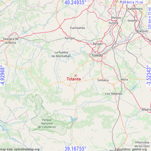
Totanés GPS coordinates[2]
39° 42' 38.052" North, 4° 13' 35.58" West
| Map corner | latitude | longitude |
|---|---|---|
| Upper-left | 40.24935°, | -4.92968° |
| Center: | 39.71057°, | -4.22655° |
| Lower-right: | 39.16755°, | -3.52343° |
| Map W x H: | 120.3×120.3 km | = 74.8×74.8mi |
| max Lat: | 43.74134° ⇑74.2% North |
| Totanés: | 39.71057° |
| min Lat: | ⇓25.8% South 27.64134° |
| min Long | Totanés | max Long |
| -18.00367° | -4.22655° | 4.2899° |
| W 37.1%⇐ | ⇒62.9% E |
Elevation
Elevation of Totanés is 726 m = 2382 ft, and this is 128 m = 420 ft above average elevation for this country.
| Max E: |
1682 m = 5518 ft | 42.6% |
| Totanés | 726 m 2382 ft | |
| Avg. | 598 m = 1962 ft | |
Min E: |
0 m = 0 ft | 57.4% |
See also: Spain elevation on elevation.city.
Geographical zone
Totanés is located in North temperate zone (between Tropic of Cancer and the Arctic Circle). Distance of this Northern Tropic circle is 1809.5 km =1124.4 mi to South.| Distance of | km | miles | from Totanés |
|---|---|---|---|
| North Pole | 5591.7 | 3474.5 | to North |
| Arctic Circle | 2985.8 | 1855.3 | to North |
| Tropic Cancer | 1809.5 | 1124.4 | to South |
| Equator | 4415.4 | 2743.6 | to South |


Nearby cities:
15 places around Totanés: (largest is in red/bold)
• Albarreal de Tajo
20.7 km =12.9 mi,  359°
359°
• Casasbuenas
10.3 km =6.4 mi,  56°
56°
• Cobisa
20.1 km =12.5 mi, 58°
• Cuerva
5.4 km =3.4 mi,  165°
165°
• Guadamur
13.1 km =8.1 mi,  30°
30°
• Gálvez
4 km =2.5 mi,  256°
256°
• La Puebla de Montalbán
20.4 km =12.7 mi,  326°
326°
• Layos
15.7 km =9.8 mi, 61°
• Mazarambroz
17.8 km =11.1 mi,  95°
95°
• Menasalbas
9.3 km =5.8 mi,  211°
211°
• Noez
5 km =3.1 mi,  47°
47°
• Polán
9.9 km =6.2 mi, 30°
• Pulgar
6.6 km =4.1 mi,  106°
106°
• San Martín de Montalbán
13.8 km =8.6 mi,  265°
265°
• Ventas con Peña Aguilera
11.2 km =7 mi,  182°
182°
Sources, notices
• [Note1] Compared only with cities in Spain existing in our database
• [Src1] Map data: © OpenStreetMap contributors (CC-BY-SA)
• [Src2] Other city data from geonames.org with taken over terms of usage.
• [Src3] Geographical zone / Annual Mean Temperature by Robert A. Rohde @ Wikipedia
