Albarreal de Tajo geodata
Albarreal de Tajo (Castille-La Mancha) is a seat of a third-order administrative division; located in Spain in Europe/Madrid (GMT+2) time zone. With population of 670 people, there are 3465 cities with bigger population in this country. Compared to other cities in Spain, 71.7% of cities are located further ↑North; 63% of cities are located further →East and 65.7% of cities have higher elevation than Albarreal de Tajo. Note1
Administrative division(s):
- Level 1: Castille-La Mancha
- Level 2: Province of Toledo
- Level 3: Albarreal de Tajo


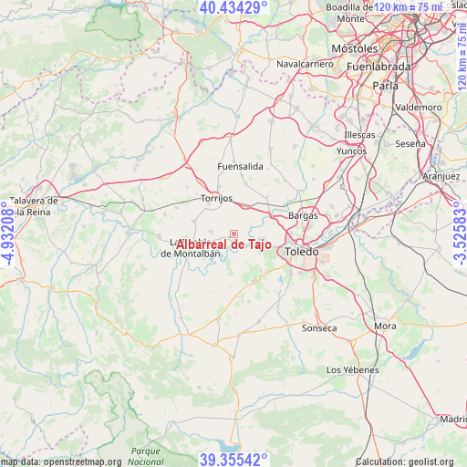
Albarreal de Tajo GPS coordinates[2]
39° 53' 49.128" North, 4° 13' 44.22" West
| Map corner | latitude | longitude |
|---|---|---|
| Upper-left | 40.43429°, | -4.93208° |
| Center: | 39.89698°, | -4.22895° |
| Lower-right: | 39.35542°, | -3.52583° |
| Map W x H: | 120×120 km | = 74.6×74.6mi |
| max Lat: | 43.74134° ⇑71.7% North |
| Albarreal de Tajo: | 39.89698° |
| min Lat: | ⇓28.3% South 27.64134° |
| min Long | Albarreal de Ta | max Long |
| -18.00367° | -4.22895° | 4.2899° |
| W 37%⇐ | ⇒63% E |
Elevation
Elevation of Albarreal de Tajo is 451 m = 1480 ft, and this is 147 m = 482 ft below average elevation for this country.
| Max E: |
1682 m = 5518 ft | 65.7% |
| Avg. | 598 m = 1962 ft | |
| Albarreal de Tajo | 451 m = 1480 ft | |
Min E: |
0 m = 0 ft | 34.3% |
See also: Spain elevation on elevation.city.
Geographical zone
Albarreal de Tajo is located in North temperate zone (between Tropic of Cancer and the Arctic Circle). Distance of this Northern Tropic circle is 1830.2 km =1137.2 mi to South.| Distance of | km | miles | from Albarreal de Tajo |
|---|---|---|---|
| North Pole | 5570.9 | 3461.6 | to North |
| Arctic Circle | 2965 | 1842.4 | to North |
| Tropic Cancer | 1830.2 | 1137.2 | to South |
| Equator | 4436.1 | 2756.5 | to South |


Nearby cities:
15 places around Albarreal de Tajo: (largest is in red/bold)
• Alcabón
16.7 km =10.4 mi,  314°
314°
• Barcience
9.7 km =6 mi,  357°
357°
• Burujón
5.8 km =3.6 mi,  274°
274°
• Carmena
16.1 km =10 mi,  293°
293°
• Escalonilla
10.9 km =6.8 mi, 287°
• Fuensalida
17.4 km =10.8 mi,  6°
6°
• Gerindote
9.9 km =6.2 mi,  320°
320°
• Guadamur
11.7 km =7.3 mi,  144°
144°
• Huecas
13.1 km =8.1 mi, 12°
• La Puebla de Montalbán
11.7 km =7.3 mi,  251°
251°
• Novés
17.2 km =10.7 mi,  346°
346°
• Polán
13.2 km =8.2 mi,  156°
156°
• Rielves
7.9 km =4.9 mi,  22°
22°
• Torrijos
10.5 km =6.5 mi,  333°
333°
• Villamiel de Toledo
11.6 km =7.2 mi,  49°
49°
Sources, notices
• [Note1] Compared only with cities in Spain existing in our database
• [Src1] Map data: © OpenStreetMap contributors (CC-BY-SA)
• [Src2] Other city data from geonames.org with taken over terms of usage.
• [Src3] Geographical zone / Annual Mean Temperature by Robert A. Rohde @ Wikipedia
