Gálvez geodata
Gálvez (Castille-La Mancha) is a seat of a third-order administrative division; located in Spain in Europe/Madrid (GMT+2) time zone. With population of 3,363 people, there are 1617 cities with bigger population in this country. Compared to other cities in Spain, 74.4% of cities are located further ↑North; 63.5% of cities are located further →East and 55.6% of cities have lower elevation than Gálvez. Note1


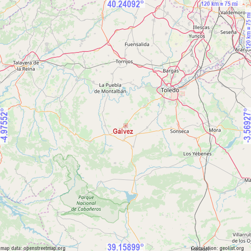
Gálvez GPS coordinates[2]
39° 42' 7.488" North, 4° 16' 20.604" West
| Map corner | latitude | longitude |
|---|---|---|
| Upper-left | 40.24092°, | -4.97552° |
| Center: | 39.70208°, | -4.27239° |
| Lower-right: | 39.15899°, | -3.56927° |
| Map W x H: | 120.3×120.3 km | = 74.8×74.8mi |
| max Lat: | 43.74134° ⇑74.4% North |
| Gálvez: | 39.70208° |
| min Lat: | ⇓25.6% South 27.64134° |
| min Long | Gálvez | max Long |
| -18.00367° | -4.27239° | 4.2899° |
| W 36.5%⇐ | ⇒63.5% E |
Elevation
Elevation of Gálvez is 713 m = 2339 ft, and this is 115 m = 377 ft above average elevation for this country.
| Max E: |
1682 m = 5518 ft | 44.4% |
| Gálvez | 713 m 2339 ft | |
| Avg. | 598 m = 1962 ft | |
Min E: |
0 m = 0 ft | 55.6% |
See also: Spain elevation on elevation.city.
Geographical zone
Gálvez is located in North temperate zone (between Tropic of Cancer and the Arctic Circle). Distance of this Northern Tropic circle is 1808.5 km =1123.7 mi to South.| Distance of | km | miles | from Gálvez |
|---|---|---|---|
| North Pole | 5592.6 | 3475.1 | to North |
| Arctic Circle | 2986.7 | 1855.8 | to North |
| Tropic Cancer | 1808.5 | 1123.7 | to South |
| Equator | 4414.5 | 2743 | to South |


Nearby cities:
15 places around Gálvez: (largest is in red/bold)
• Casasbuenas
14.2 km =8.8 mi,  62°
62°
• Cuerva
6.8 km =4.2 mi,  128°
128°
• Guadamur
16.1 km =10 mi,  40°
40°
• Hontanar
21.6 km =13.4 mi,  242°
242°
• La Puebla de Montalbán
19.4 km =12.1 mi,  337°
337°
• Layos
19.6 km =12.2 mi, 64°
• Mazarambroz
21.6 km =13.4 mi,  92°
92°
• Menasalbas
7 km =4.3 mi,  188°
188°
• Navahermosa
18.5 km =11.5 mi,  246°
246°
• Noez
8.7 km =5.4 mi, 60°
• Polán
13 km =8.1 mi, 43°
• Pulgar
10.3 km =6.4 mi,  95°
95°
• San Martín de Montalbán
9.9 km =6.2 mi,  269°
269°
• Totanés
4 km =2.5 mi,  76°
76°
• Ventas con Peña Aguilera
10.8 km =6.7 mi,  160°
160°
Sources, notices
• [Note1] Compared only with cities in Spain existing in our database
• [Src1] Map data: © OpenStreetMap contributors (CC-BY-SA)
• [Src2] Other city data from geonames.org with taken over terms of usage.
• [Src3] Geographical zone / Annual Mean Temperature by Robert A. Rohde @ Wikipedia
