Rioja geodata
Rioja (Andalusia) is a seat of a third-order administrative division; located in Spain in Europe/Madrid (GMT+2) time zone. With population of 1,331 people, there are 2612 cities with bigger population in this country. Compared to other cities in Spain, 95.8% of cities are located further ↑North; 61.4% of cities are located further ←West and 85.3% of cities have higher elevation than Rioja. Note1


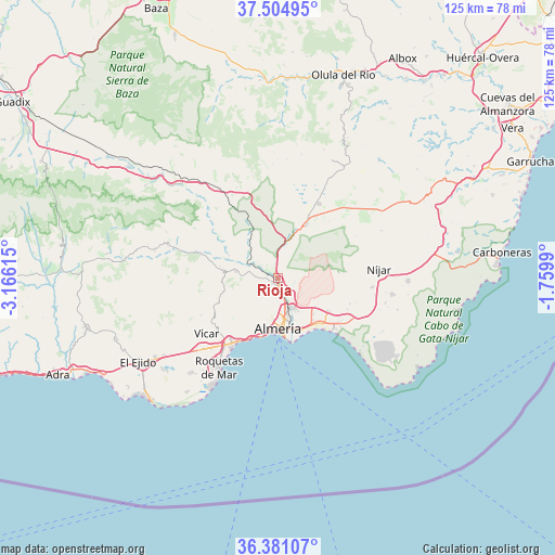
Rioja GPS coordinates[2]
36° 56' 42.288" North, 2° 27' 46.872" West
| Map corner | latitude | longitude |
|---|---|---|
| Upper-left | 37.50495°, | -3.16615° |
| Center: | 36.94508°, | -2.46302° |
| Lower-right: | 36.38107°, | -1.7599° |
| Map W x H: | 125×125 km | = 77.7×77.7mi |
| max Lat: | 43.74134° ⇑95.8% North |
| Rioja: | 36.94508° |
| min Lat: | ⇓4.2% South 27.64134° |
| min Long | Rioja | max Long |
| -18.00367° | -2.46302° | 4.2899° |
| W 61.4%⇐ | ⇒38.6% E |
Elevation
Elevation of Rioja is 133 m = 436 ft, and this is 465 m = 1526 ft below average elevation for this country.
| Max E: |
1682 m = 5518 ft | 85.3% |
| Avg. | 598 m = 1962 ft | |
| Rioja | 133 m = 436 ft | |
Min E: |
0 m = 0 ft | 14.7% |
See also: Spain elevation on elevation.city.
Geographical zone
Rioja is located in North temperate zone (between Tropic of Cancer and the Arctic Circle). Distance of this Northern Tropic circle is 1502 km =933.3 mi to South.| Distance of | km | miles | from Rioja |
|---|---|---|---|
| North Pole | 5899.2 | 3665.6 | to North |
| Arctic Circle | 3293.3 | 2046.4 | to North |
| Tropic Cancer | 1502 | 933.3 | to South |
| Equator | 4107.9 | 2552.5 | to South |


Nearby cities:
15 places around Rioja: (largest is in red/bold)
• Alhabia
12.1 km =7.5 mi,  294°
294°
• Alhama de Almería
9.5 km =5.9 mi,  277°
277°
• Alicún
12.6 km =7.8 mi, 280°
• Almería
11.9 km =7.4 mi,  178°
178°
• Alsodux
13.3 km =8.3 mi,  298°
298°
• Benahadux
2.3 km =1.4 mi,  171°
171°
• Costacabana
14 km =8.7 mi,  148°
148°
• Gádor
2.8 km =1.7 mi, 289°
• Huécija
13.3 km =8.3 mi, 281°
• Huércal de Almería
7 km =4.3 mi,  161°
161°
• Pechina
4 km =2.5 mi,  144°
144°
• Santa Fe de Mondújar
6.9 km =4.3 mi, 298°
• Tabernas
13.3 km =8.3 mi,  28°
28°
• Terque
12.6 km =7.8 mi, 289°
• Viator
6.9 km =4.3 mi, 152°
Sources, notices
• [Note1] Compared only with cities in Spain existing in our database
• [Src1] Map data: © OpenStreetMap contributors (CC-BY-SA)
• [Src2] Other city data from geonames.org with taken over terms of usage.
• [Src3] Geographical zone / Annual Mean Temperature by Robert A. Rohde @ Wikipedia
