Benzú geodata
Benzú (Ceuta) is a populated place; located in Spain in Europe/Madrid (GMT+2) time zone. With population of 1,987 people, there are 2180 cities with bigger population in this country. Compared to other cities in Spain, 98.3% of cities are located further ↑North; 77.1% of cities are located further →East and 99.8% of cities have higher elevation than Benzú. Note1


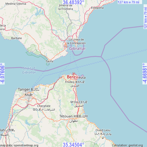
Benzú GPS coordinates[2]
35° 54' 59.508" North, 5° 22' 22.548" West
| Map corner | latitude | longitude |
|---|---|---|
| Upper-left | 36.48392°, | -6.07606° |
| Center: | 35.91653°, | -5.37293° |
| Lower-right: | 35.34504°, | -4.66981° |
| Map W x H: | 126.6×126.6 km | = 78.7×78.7mi |
| max Lat: | 43.74134° ⇑98.3% North |
| Benzú: | 35.91653° |
| min Lat: | ⇓1.7% South 27.64134° |
| min Long | Benzú | max Long |
| -18.00367° | -5.37293° | 4.2899° |
| W 22.9%⇐ | ⇒77.1% E |
Elevation
Elevation of Benzú is 3 m = 10 ft, and this is 595 m = 1952 ft below average elevation for this country.
| Max E: |
1682 m = 5518 ft | 99.8% |
| Avg. | 598 m = 1962 ft | |
| Benzú | 3 m = 10 ft | |
Min E: |
0 m = 0 ft | 0.2% |
See also: Spain elevation on elevation.city.
Geographical zone
Benzú is located in North temperate zone (between Tropic of Cancer and the Arctic Circle). Distance of this Northern Tropic circle is 1387.6 km =862.2 mi to South.| Distance of | km | miles | from Benzú |
|---|---|---|---|
| North Pole | 6013.5 | 3736.6 | to North |
| Arctic Circle | 3407.6 | 2117.4 | to North |
| Tropic Cancer | 1387.6 | 862.2 | to South |
| Equator | 3993.5 | 2481.4 | to South |


Nearby cities:
15 places around Benzú: (largest is in red/bold)
• Algeciras
25.1 km =15.6 mi,  343°
343°
• Barbate
58.1 km =36.1 mi,  301°
301°
• Benalup-Casas Viejas
61.8 km =38.4 mi,  320°
320°
• Casares
59.5 km =37 mi,  7°
7°
• Castellar de la Frontera
45.2 km =28.1 mi,  350°
350°
• Ceuta
5.6 km =3.5 mi,  122°
122°
• Estepona
60.4 km =37.5 mi,  19°
19°
• Jimena de la Frontera
58.1 km =36.1 mi, 352°
• La Línea de la Concepción
28.1 km =17.5 mi,  4°
4°
• Los Barrios
31.7 km =19.7 mi, 340°
• Manilva
52.3 km =32.5 mi, 12°
• San Enrique de Guadiaro
43.8 km =27.2 mi, 9°
• San Roque
32.7 km =20.3 mi,  358°
358°
• Tarifa
23.7 km =14.7 mi, 297°
• Zahara de los Atunes
49.1 km =30.5 mi, 299°
Sources, notices
• [Note1] Compared only with cities in Spain existing in our database
• [Src1] Map data: © OpenStreetMap contributors (CC-BY-SA)
• [Src2] Other city data from geonames.org with taken over terms of usage.
• [Src3] Geographical zone / Annual Mean Temperature by Robert A. Rohde @ Wikipedia
