Sorbas geodata
Sorbas (Andalusia) is a seat of a third-order administrative division; located in Spain in Europe/Madrid (GMT+2) time zone. With population of 2,679 people, there are 1825 cities with bigger population in this country. Compared to other cities in Spain, 94.8% of cities are located further ↑North; 65.8% of cities are located further ←West and 68.9% of cities have higher elevation than Sorbas. Note1


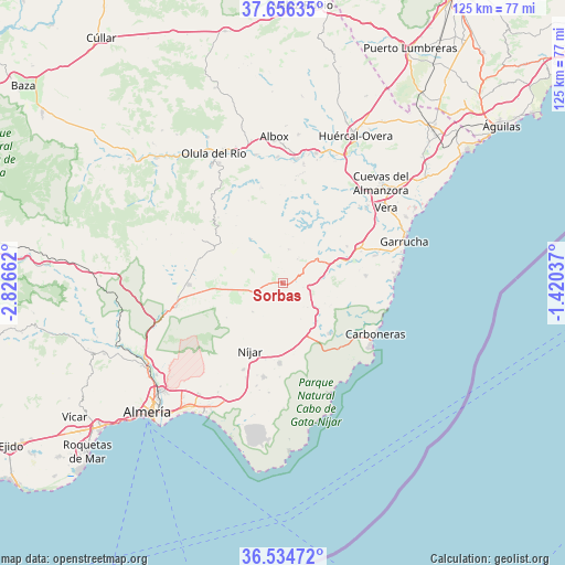
Sorbas GPS coordinates[2]
37° 5' 51.396" North, 2° 7' 24.564" West
| Map corner | latitude | longitude |
|---|---|---|
| Upper-left | 37.65635°, | -2.82662° |
| Center: | 37.09761°, | -2.12349° |
| Lower-right: | 36.53472°, | -1.42037° |
| Map W x H: | 124.7×124.7 km | = 77.5×77.5mi |
| max Lat: | 43.74134° ⇑94.8% North |
| Sorbas: | 37.09761° |
| min Lat: | ⇓5.2% South 27.64134° |
| min Long | Sorbas | max Long |
| -18.00367° | -2.12349° | 4.2899° |
| W 65.8%⇐ | ⇒34.2% E |
Elevation
Elevation of Sorbas is 399 m = 1309 ft, and this is 199 m = 653 ft below average elevation for this country.
| Max E: |
1682 m = 5518 ft | 68.9% |
| Avg. | 598 m = 1962 ft | |
| Sorbas | 399 m = 1309 ft | |
Min E: |
0 m = 0 ft | 31.1% |
See also: Spain elevation on elevation.city.
Geographical zone
Sorbas is located in North temperate zone (between Tropic of Cancer and the Arctic Circle). Distance of this Northern Tropic circle is 1518.9 km =943.8 mi to South.| Distance of | km | miles | from Sorbas |
|---|---|---|---|
| North Pole | 5882.2 | 3655 | to North |
| Arctic Circle | 3276.3 | 2035.8 | to North |
| Tropic Cancer | 1518.9 | 943.8 | to South |
| Equator | 4124.9 | 2563.1 | to South |


Nearby cities:
15 places around Sorbas: (largest is in red/bold)
• Albánchez
21.3 km =13.2 mi,  345°
345°
• Alcudia de Monteagud
19.9 km =12.4 mi,  320°
320°
• Benitagla
18.1 km =11.2 mi,  325°
325°
• Benizalón
16.5 km =10.3 mi, 320°
• Bédar
16.5 km =10.3 mi,  49°
49°
• Carboneras
23.1 km =14.4 mi,  119°
119°
• Chercos
21.6 km =13.4 mi, 323°
• Cóbdar
19.8 km =12.3 mi,  336°
336°
• Lubrín
14 km =8.7 mi,  20°
20°
• Lucainena de las Torres
9.4 km =5.8 mi,  227°
227°
• Níjar
16.3 km =10.1 mi,  206°
206°
• Tahal
20.4 km =12.7 mi, 315°
• Turre
21.2 km =13.2 mi,  73°
73°
• Turrillas
14.7 km =9.1 mi,  239°
239°
• Uleila del Campo
12.1 km =7.5 mi, 323°
Sources, notices
• [Note1] Compared only with cities in Spain existing in our database
• [Src1] Map data: © OpenStreetMap contributors (CC-BY-SA)
• [Src2] Other city data from geonames.org with taken over terms of usage.
• [Src3] Geographical zone / Annual Mean Temperature by Robert A. Rohde @ Wikipedia
