Lubrín geodata
Lubrín (Andalusia) is a seat of a third-order administrative division; located in Spain in Europe/Madrid (GMT+2) time zone. With population of 1,687 people, there are 2348 cities with bigger population in this country. Compared to other cities in Spain, 93.9% of cities are located further ↑North; 66.7% of cities are located further ←West and 60.6% of cities have higher elevation than Lubrín. Note1


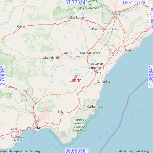
Lubrín GPS coordinates[2]
37° 12' 55.368" North, 2° 4' 0.372" West
| Map corner | latitude | longitude |
|---|---|---|
| Upper-left | 37.77324°, | -2.76989° |
| Center: | 37.21538°, | -2.06677° |
| Lower-right: | 36.65336°, | -1.36364° |
| Map W x H: | 124.5×124.5 km | = 77.4×77.4mi |
| max Lat: | 43.74134° ⇑93.9% North |
| Lubrín: | 37.21538° |
| min Lat: | ⇓6.1% South 27.64134° |
| min Long | Lubrín | max Long |
| -18.00367° | -2.06677° | 4.2899° |
| W 66.7%⇐ | ⇒33.3% E |
Elevation
Elevation of Lubrín is 519 m = 1703 ft, and this is 79 m = 259 ft below average elevation for this country.
| Max E: |
1682 m = 5518 ft | 60.6% |
| Avg. | 598 m = 1962 ft | |
| Lubrín | 519 m = 1703 ft | |
Min E: |
0 m = 0 ft | 39.4% |
See also: Spain elevation on elevation.city.
Geographical zone
Lubrín is located in North temperate zone (between Tropic of Cancer and the Arctic Circle). Distance of this Northern Tropic circle is 1532 km =951.9 mi to South.| Distance of | km | miles | from Lubrín |
|---|---|---|---|
| North Pole | 5869.1 | 3646.9 | to North |
| Arctic Circle | 3263.2 | 2027.7 | to North |
| Tropic Cancer | 1532 | 951.9 | to South |
| Equator | 4138 | 2571.2 | to South |


Nearby cities:
15 places around Lubrín: (largest is in red/bold)
• Albánchez
12.7 km =7.9 mi,  306°
306°
• Alcudia de Monteagud
17.8 km =11.1 mi,  277°
277°
• Antas
13.6 km =8.5 mi,  75°
75°
• Arboleas
15 km =9.3 mi,  357°
357°
• Benitagla
15.4 km =9.6 mi, 276°
• Benizalón
15.5 km =9.6 mi,  268°
268°
• Bédar
7.9 km =4.9 mi,  107°
107°
• Chercos
18.2 km =11.3 mi, 283°
• Cuevas del Almanzora
18.7 km =11.6 mi,  61°
61°
• Cóbdar
13.8 km =8.6 mi,  291°
291°
• Sorbas
14 km =8.7 mi,  200°
200°
• Turre
16.8 km =10.4 mi, 114°
• Uleila del Campo
12.7 km =7.9 mi,  254°
254°
• Vera
18.7 km =11.6 mi, 80°
• Zurgena
14.3 km =8.9 mi,  9°
9°
Sources, notices
• [Note1] Compared only with cities in Spain existing in our database
• [Src1] Map data: © OpenStreetMap contributors (CC-BY-SA)
• [Src2] Other city data from geonames.org with taken over terms of usage.
• [Src3] Geographical zone / Annual Mean Temperature by Robert A. Rohde @ Wikipedia
