Uleila del Campo geodata
Uleila del Campo (Andalusia) is a seat of a third-order administrative division; located in Spain in Europe/Madrid (GMT+2) time zone. With population of 953 people, there are 3009 cities with bigger population in this country. Compared to other cities in Spain, 94.2% of cities are located further ↑North; 64.6% of cities are located further ←West and 53.5% of cities have higher elevation than Uleila del Campo. Note1


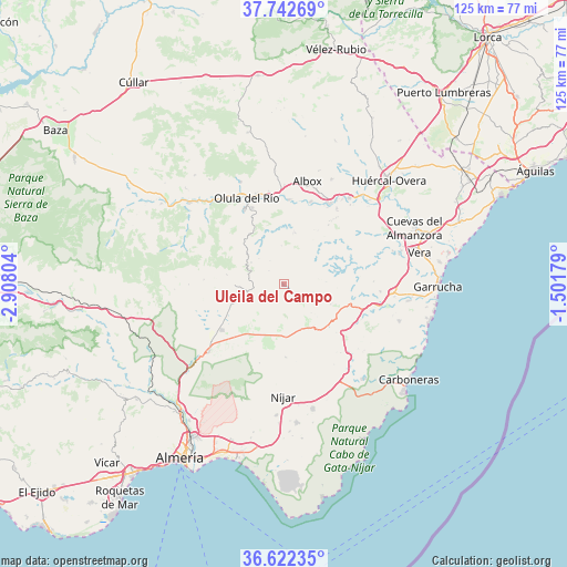
Uleila del Campo GPS coordinates[2]
37° 11' 4.56" North, 2° 12' 17.676" West
| Map corner | latitude | longitude |
|---|---|---|
| Upper-left | 37.74269°, | -2.90804° |
| Center: | 37.1846°, | -2.20491° |
| Lower-right: | 36.62235°, | -1.50179° |
| Map W x H: | 124.6×124.6 km | = 77.4×77.4mi |
| max Lat: | 43.74134° ⇑94.2% North |
| Uleila del Campo: | 37.1846° |
| min Lat: | ⇓5.8% South 27.64134° |
| min Long | Uleila del Camp | max Long |
| -18.00367° | -2.20491° | 4.2899° |
| W 64.6%⇐ | ⇒35.4% E |
Elevation
Elevation of Uleila del Campo is 618 m = 2028 ft, and this is 20 m = 66 ft above average elevation for this country.
| Max E: |
1682 m = 5518 ft | 53.5% |
| Uleila del Campo | 618 m 2028 ft | |
| Avg. | 598 m = 1962 ft | |
Min E: |
0 m = 0 ft | 46.5% |
See also: Spain elevation on elevation.city.
Geographical zone
Uleila del Campo is located in North temperate zone (between Tropic of Cancer and the Arctic Circle). Distance of this Northern Tropic circle is 1528.6 km =949.8 mi to South.| Distance of | km | miles | from Uleila del Campo |
|---|---|---|---|
| North Pole | 5872.5 | 3649 | to North |
| Arctic Circle | 3266.6 | 2029.8 | to North |
| Tropic Cancer | 1528.6 | 949.8 | to South |
| Equator | 4134.5 | 2569.1 | to South |


Nearby cities:
15 places around Uleila del Campo: (largest is in red/bold)
• Albánchez
11.2 km =7 mi,  10°
10°
• Alcudia de Monteagud
7.8 km =4.8 mi,  315°
315°
• Benitagla
6 km =3.7 mi,  329°
329°
• Benizalón
4.5 km =2.8 mi,  313°
313°
• Cantoria
18.6 km =11.6 mi,  3°
3°
• Chercos
9.5 km =5.9 mi, 324°
• Cóbdar
8.6 km =5.3 mi,  356°
356°
• Laroya
17 km =10.6 mi, 317°
• Lubrín
12.7 km =7.9 mi,  74°
74°
• Lucainena de las Torres
16 km =9.9 mi,  178°
178°
• Macael
18.6 km =11.6 mi, 332°
• Sorbas
12.1 km =7.5 mi,  143°
143°
• Tahal
8.6 km =5.3 mi,  304°
304°
• Turrillas
18.1 km =11.2 mi,  197°
197°
• Velefique
17.4 km =10.8 mi,  273°
273°
Sources, notices
• [Note1] Compared only with cities in Spain existing in our database
• [Src1] Map data: © OpenStreetMap contributors (CC-BY-SA)
• [Src2] Other city data from geonames.org with taken over terms of usage.
• [Src3] Geographical zone / Annual Mean Temperature by Robert A. Rohde @ Wikipedia
