Albánchez geodata
Albánchez (Andalusia) is a seat of a third-order administrative division; located in Spain in Europe/Madrid (GMT+2) time zone. With population of 747 people, there are 3309 cities with bigger population in this country. Compared to other cities in Spain, 93.1% of cities are located further ↑North; 65% of cities are located further ←West and 61.6% of cities have higher elevation than Albánchez. Note1


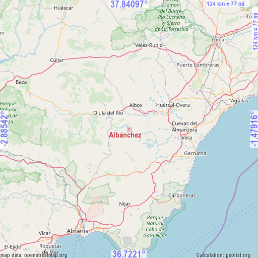
Albánchez GPS coordinates[2]
37° 17' 0.996" North, 2° 10' 56.244" West
| Map corner | latitude | longitude |
|---|---|---|
| Upper-left | 37.84097°, | -2.88542° |
| Center: | 37.28361°, | -2.18229° |
| Lower-right: | 36.7221°, | -1.47916° |
| Map W x H: | 124.4×124.4 km | = 77.3×77.3mi |
| max Lat: | 43.74134° ⇑93.1% North |
| Albánchez: | 37.28361° |
| min Lat: | ⇓6.9% South 27.64134° |
| min Long | Albánchez | max Long |
| -18.00367° | -2.18229° | 4.2899° |
| W 65%⇐ | ⇒35% E |
Elevation
Elevation of Albánchez is 503 m = 1650 ft, and this is 95 m = 312 ft below average elevation for this country.
| Max E: |
1682 m = 5518 ft | 61.6% |
| Avg. | 598 m = 1962 ft | |
| Albánchez | 503 m = 1650 ft | |
Min E: |
0 m = 0 ft | 38.4% |
See also: Spain elevation on elevation.city.
Geographical zone
Albánchez is located in North temperate zone (between Tropic of Cancer and the Arctic Circle). Distance of this Northern Tropic circle is 1539.6 km =956.7 mi to South.| Distance of | km | miles | from Albánchez |
|---|---|---|---|
| North Pole | 5861.5 | 3642.2 | to North |
| Arctic Circle | 3255.6 | 2022.9 | to North |
| Tropic Cancer | 1539.6 | 956.7 | to South |
| Equator | 4145.5 | 2575.9 | to South |


Nearby cities:
15 places around Albánchez: (largest is in red/bold)
• Albox
12 km =7.5 mi,  13°
13°
• Alcudia de Monteagud
9.2 km =5.7 mi,  234°
234°
• Arboleas
12.1 km =7.5 mi,  52°
52°
• Benitagla
7.7 km =4.8 mi,  221°
221°
• Benizalón
9.5 km =5.9 mi,  213°
213°
• Cantoria
7.6 km =4.7 mi,  353°
353°
• Chercos
8.1 km =5 mi,  246°
246°
• Cóbdar
3.5 km =2.2 mi, 226°
• Fines
10.9 km =6.8 mi,  321°
321°
• Laroya
13.5 km =8.4 mi,  276°
276°
• Lubrín
12.7 km =7.9 mi,  126°
126°
• Macael
11.8 km =7.3 mi,  297°
297°
• Olula del Río
12.9 km =8 mi,  307°
307°
• Tahal
11 km =6.8 mi,  235°
235°
• Uleila del Campo
11.2 km =7 mi,  190°
190°
Sources, notices
• [Note1] Compared only with cities in Spain existing in our database
• [Src1] Map data: © OpenStreetMap contributors (CC-BY-SA)
• [Src2] Other city data from geonames.org with taken over terms of usage.
• [Src3] Geographical zone / Annual Mean Temperature by Robert A. Rohde @ Wikipedia
