Ricote geodata
Ricote (Murcia) is a seat of a third-order administrative division; located in Spain in Europe/Madrid (GMT+2) time zone. With population of 1,492 people, there are 2470 cities with bigger population in this country. Compared to other cities in Spain, 87.4% of cities are located further ↑North; 74.1% of cities are located further ←West and 75.3% of cities have higher elevation than Ricote. Note1


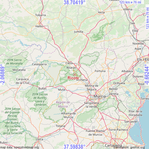
Ricote GPS coordinates[2]
38° 9' 12.168" North, 1° 21' 56.052" West
| Map corner | latitude | longitude |
|---|---|---|
| Upper-left | 38.70419°, | -2.06869° |
| Center: | 38.15338°, | -1.36557° |
| Lower-right: | 37.59838°, | -0.66244° |
| Map W x H: | 123×123 km | = 76.4×76.4mi |
| max Lat: | 43.74134° ⇑87.4% North |
| Ricote: | 38.15338° |
| min Lat: | ⇓12.6% South 27.64134° |
| min Long | Ricote | max Long |
| -18.00367° | -1.36557° | 4.2899° |
| W 74.1%⇐ | ⇒25.9% E |
Elevation
Elevation of Ricote is 294 m = 965 ft, and this is 304 m = 997 ft below average elevation for this country.
| Max E: |
1682 m = 5518 ft | 75.3% |
| Avg. | 598 m = 1962 ft | |
| Ricote | 294 m = 965 ft | |
Min E: |
0 m = 0 ft | 24.7% |
See also: Spain elevation on elevation.city.
Geographical zone
Ricote is located in North temperate zone (between Tropic of Cancer and the Arctic Circle). Distance of this Northern Tropic circle is 1636.3 km =1016.7 mi to South.| Distance of | km | miles | from Ricote |
|---|---|---|---|
| North Pole | 5764.8 | 3582.1 | to North |
| Arctic Circle | 3158.9 | 1962.8 | to North |
| Tropic Cancer | 1636.3 | 1016.7 | to South |
| Equator | 4242.3 | 2636 | to South |


Nearby cities:
15 places around Ricote: (largest is in red/bold)
• Abarán
6.5 km =4 mi,  333°
333°
• Albudeite
14 km =8.7 mi,  187°
187°
• Alguazas
15 km =9.3 mi,  137°
137°
• Archena
7 km =4.3 mi,  125°
125°
• Blanca
3 km =1.9 mi,  344°
344°
• Campos del Río
12.7 km =7.9 mi,  175°
175°
• Ceuti
11.5 km =7.1 mi, 136°
• Cieza
10.7 km =6.6 mi, 333°
• Fortuna
21.2 km =13.2 mi,  81°
81°
• Las Torres de Cotillas
17.6 km =10.9 mi, 142°
• Lorquí
12.7 km =7.9 mi, 128°
• Molina de Segura
17.7 km =11 mi, 128°
• Mula
16.6 km =10.3 mi,  221°
221°
• Ojós
2.1 km =1.3 mi,  109°
109°
• Ulea
3.4 km =2.1 mi, 114°
Sources, notices
• [Note1] Compared only with cities in Spain existing in our database
• [Src1] Map data: © OpenStreetMap contributors (CC-BY-SA)
• [Src2] Other city data from geonames.org with taken over terms of usage.
• [Src3] Geographical zone / Annual Mean Temperature by Robert A. Rohde @ Wikipedia
