Archena geodata
Archena (Murcia) is a seat of a third-order administrative division; located in Spain in Europe/Madrid (GMT+2) time zone. With population of 18,202 people, there are 514 cities with bigger population in this country. Compared to other cities in Spain, 87.7% of cities are located further ↑North; 74.7% of cities are located further ←West and 86.3% of cities have higher elevation than Archena. Note1


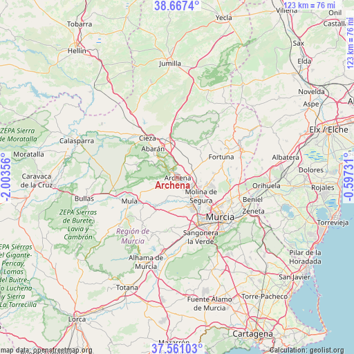
Archena GPS coordinates[2]
38° 6' 58.716" North, 1° 18' 1.548" West
| Map corner | latitude | longitude |
|---|---|---|
| Upper-left | 38.6674°, | -2.00356° |
| Center: | 38.11631°, | -1.30043° |
| Lower-right: | 37.56103°, | -0.59731° |
| Map W x H: | 123×123 km | = 76.4×76.4mi |
| max Lat: | 43.74134° ⇑87.7% North |
| Archena: | 38.11631° |
| min Lat: | ⇓12.3% South 27.64134° |
| min Long | Archena | max Long |
| -18.00367° | -1.30043° | 4.2899° |
| W 74.7%⇐ | ⇒25.3% E |
Elevation
Elevation of Archena is 118 m = 387 ft, and this is 480 m = 1575 ft below average elevation for this country.
| Max E: |
1682 m = 5518 ft | 86.3% |
| Avg. | 598 m = 1962 ft | |
| Archena | 118 m = 387 ft | |
Min E: |
0 m = 0 ft | 13.7% |
See also: Spain elevation on elevation.city.
Geographical zone
Archena is located in North temperate zone (between Tropic of Cancer and the Arctic Circle). Distance of this Northern Tropic circle is 1632.2 km =1014.2 mi to South.| Distance of | km | miles | from Archena |
|---|---|---|---|
| North Pole | 5768.9 | 3584.6 | to North |
| Arctic Circle | 3163 | 1965.4 | to North |
| Tropic Cancer | 1632.2 | 1014.2 | to South |
| Equator | 4238.1 | 2633.4 | to South |


Nearby cities:
15 places around Archena: (largest is in red/bold)
• Abarán
13.1 km =8.1 mi,  318°
318°
• Albudeite
12.3 km =7.6 mi,  217°
217°
• Alcantarilla
17.9 km =11.1 mi,  155°
155°
• Alguazas
8.2 km =5.1 mi,  147°
147°
• Blanca
9.5 km =5.9 mi, 317°
• Campos del Río
9.7 km =6 mi,  208°
208°
• Ceuti
4.8 km =3 mi, 151°
• Cieza
17.3 km =10.7 mi, 322°
• Fortuna
16.9 km =10.5 mi,  64°
64°
• Las Torres de Cotillas
11.1 km =6.9 mi, 152°
• Lorquí
5.7 km =3.5 mi,  130°
130°
• Molina de Segura
10.6 km =6.6 mi, 130°
• Ojós
5 km =3.1 mi,  312°
312°
• Ricote
7 km =4.3 mi, 305°
• Ulea
3.7 km =2.3 mi, 315°
Sources, notices
• [Note1] Compared only with cities in Spain existing in our database
• [Src1] Map data: © OpenStreetMap contributors (CC-BY-SA)
• [Src2] Other city data from geonames.org with taken over terms of usage.
• [Src3] Geographical zone / Annual Mean Temperature by Robert A. Rohde @ Wikipedia
