Las Torres de Cotillas geodata
Las Torres de Cotillas (Murcia) is a seat of a third-order administrative division; located in Spain in Europe/Madrid (GMT+2) time zone. With population of 21,062 people, there are 454 cities with bigger population in this country. Compared to other cities in Spain, 88.4% of cities are located further ↑North; 75.3% of cities are located further ←West and 88.5% of cities have higher elevation than Las Torres de Cotillas. Note1
Current local time in Las Torres de Cotillas:
09:38 PM, ThursdayDifference from your time zone: hours


Las Torres de Cotillas GPS coordinates[2]
38° 1' 41.592" North, 1° 14' 30.768" West
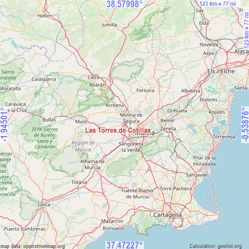
| Map corner | latitude | longitude |
|---|---|---|
| Upper-left | 38.57998°, | -1.94501° |
| Center: | 38.02822°, | -1.24188° |
| Lower-right: | 37.47227°, | -0.53876° |
| Map W x H: | 123.2×123.2 km | = 76.6×76.6mi |
| max Lat: | 43.74134° ⇑88.4% North |
| Las Torres de Cotillas: | 38.02822° |
| min Lat: | ⇓11.6% South 27.64134° |
| min Long | Las Torres de C | max Long |
| -18.00367° | -1.24188° | 4.2899° |
| W 75.3%⇐ | ⇒24.7% E |
Elevation
Elevation of Las Torres de Cotillas is 87 m = 285 ft, and this is 511 m = 1677 ft below average elevation for this country.
| Max E: |
1682 m = 5518 ft | 88.5% |
| Avg. | 598 m = 1962 ft | |
| Las Torres de Cotillas | 87 m = 285 ft | |
Min E: |
0 m = 0 ft | 11.5% |
See also: Spain elevation on elevation.city.
Geographical zone
Las Torres de Cotillas is located in North temperate zone (between Tropic of Cancer and the Arctic Circle). Distance of this Northern Tropic circle is 1622.4 km =1008.1 mi to South.| Distance of | km | miles | from Las Torres de Cotillas |
|---|---|---|---|
| North Pole | 5778.7 | 3590.7 | to North |
| Arctic Circle | 3172.8 | 1971.5 | to North |
| Tropic Cancer | 1622.4 | 1008.1 | to South |
| Equator | 4228.3 | 2627.3 | to South |


Nearby cities:
15 places around Las Torres de Cotillas: (largest is in red/bold)
• Albudeite
12.7 km =7.9 mi,  270°
270°
• Alcantarilla
6.9 km =4.3 mi,  161°
161°
• Alguazas
2.9 km =1.8 mi,  344°
344°
• Archena
11.1 km =6.9 mi,  332°
332°
• Cabecicos
14.2 km =8.8 mi,  96°
96°
• Campos del Río
9.8 km =6.1 mi,  277°
277°
• Ceuti
6.3 km =3.9 mi, 332°
• Cobatillas
14.8 km =9.2 mi,  78°
78°
• Esparragal
13.9 km =8.6 mi,  87°
87°
• Lorquí
6.1 km =3.8 mi,  352°
352°
• Molina de Segura
4.2 km =2.6 mi,  45°
45°
• Murcia
10.8 km =6.7 mi,  115°
115°
• Ojós
15.9 km =9.9 mi, 326°
• Sangonera la Verde
11.5 km =7.1 mi, 164°
• Ulea
14.7 km =9.1 mi, 328°
Sources, notices
• [Note1] Compared only with cities in Spain existing in our database
• [Src1] Map data: © OpenStreetMap contributors (CC-BY-SA)
• [Src2] Other city data from geonames.org with taken over terms of usage.
• [Src3] Geographical zone / Annual Mean Temperature by Robert A. Rohde @ Wikipedia
