Fortuna geodata
Fortuna (Murcia) is a seat of a third-order administrative division; located in Spain in Europe/Madrid (GMT+2) time zone. With population of 7,943 people, there are 942 cities with bigger population in this country. Compared to other cities in Spain, 87.3% of cities are located further ↑North; 76.1% of cities are located further ←West and 80.9% of cities have higher elevation than Fortuna. Note1


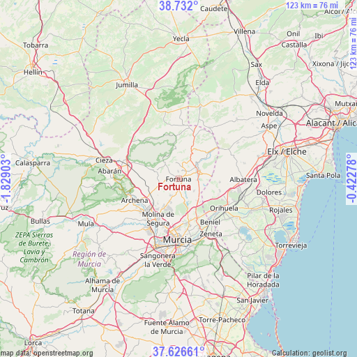
Fortuna GPS coordinates[2]
38° 10' 53.04" North, 1° 7' 33.24" West
| Map corner | latitude | longitude |
|---|---|---|
| Upper-left | 38.732°, | -1.82903° |
| Center: | 38.1814°, | -1.1259° |
| Lower-right: | 37.62661°, | -0.42278° |
| Map W x H: | 122.9×122.9 km | = 76.4×76.4mi |
| max Lat: | 43.74134° ⇑87.3% North |
| Fortuna: | 38.1814° |
| min Lat: | ⇓12.7% South 27.64134° |
| min Long | Fortuna | max Long |
| -18.00367° | -1.1259° | 4.2899° |
| W 76.1%⇐ | ⇒23.9% E |
Elevation
Elevation of Fortuna is 205 m = 673 ft, and this is 393 m = 1289 ft below average elevation for this country.
| Max E: |
1682 m = 5518 ft | 80.9% |
| Avg. | 598 m = 1962 ft | |
| Fortuna | 205 m = 673 ft | |
Min E: |
0 m = 0 ft | 19.1% |
See also: Spain elevation on elevation.city.
Geographical zone
Fortuna is located in North temperate zone (between Tropic of Cancer and the Arctic Circle). Distance of this Northern Tropic circle is 1639.5 km =1018.7 mi to South.| Distance of | km | miles | from Fortuna |
|---|---|---|---|
| North Pole | 5761.7 | 3580.2 | to North |
| Arctic Circle | 3155.8 | 1960.9 | to North |
| Tropic Cancer | 1639.5 | 1018.7 | to South |
| Equator | 4245.4 | 2638 | to South |


Nearby cities:
15 places around Fortuna: (largest is in red/bold)
• Abanilla
7.8 km =4.8 mi,  70°
70°
• Alguazas
17.9 km =11.1 mi,  217°
217°
• Archena
16.9 km =10.5 mi,  244°
244°
• Barrio de San José Obrero
18.3 km =11.4 mi,  158°
158°
• Benferri
15 km =9.3 mi,  107°
107°
• Beniel
18.5 km =11.5 mi,  144°
144°
• Cabecicos
19 km =11.8 mi,  168°
168°
• Ceuti
17.3 km =10.7 mi,  228°
228°
• Cobatillas
14.6 km =9.1 mi, 162°
• Esparragal
16.9 km =10.5 mi, 167°
• Lorquí
15.5 km =9.6 mi, 224°
• Molina de Segura
15.8 km =9.8 mi,  206°
206°
• Santa Cruz
18.7 km =11.6 mi, 161°
• Santomera
14.9 km =9.3 mi,  153°
153°
• Ulea
18.4 km =11.4 mi,  255°
255°
Sources, notices
• [Note1] Compared only with cities in Spain existing in our database
• [Src1] Map data: © OpenStreetMap contributors (CC-BY-SA)
• [Src2] Other city data from geonames.org with taken over terms of usage.
• [Src3] Geographical zone / Annual Mean Temperature by Robert A. Rohde @ Wikipedia
