Lorquí geodata
Lorquí (Murcia) is a seat of a third-order administrative division; located in Spain in Europe/Madrid (GMT+2) time zone. With population of 6,293 people, there are 1100 cities with bigger population in this country. Compared to other cities in Spain, 88% of cities are located further ↑North; 75.2% of cities are located further ←West and 86.6% of cities have higher elevation than Lorquí. Note1


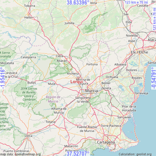
Lorquí GPS coordinates[2]
38° 4' 57.396" North, 1° 15' 3.708" West
| Map corner | latitude | longitude |
|---|---|---|
| Upper-left | 38.63396°, | -1.95416° |
| Center: | 38.08261°, | -1.25103° |
| Lower-right: | 37.52707°, | -0.54791° |
| Map W x H: | 123.1×123.1 km | = 76.5×76.5mi |
| max Lat: | 43.74134° ⇑88% North |
| Lorquí: | 38.08261° |
| min Lat: | ⇓12% South 27.64134° |
| min Long | Lorquí | max Long |
| -18.00367° | -1.25103° | 4.2899° |
| W 75.2%⇐ | ⇒24.8% E |
Elevation
Elevation of Lorquí is 114 m = 374 ft, and this is 484 m = 1588 ft below average elevation for this country.
| Max E: |
1682 m = 5518 ft | 86.6% |
| Avg. | 598 m = 1962 ft | |
| Lorquí | 114 m = 374 ft | |
Min E: |
0 m = 0 ft | 13.4% |
See also: Spain elevation on elevation.city.
Geographical zone
Lorquí is located in North temperate zone (between Tropic of Cancer and the Arctic Circle). Distance of this Northern Tropic circle is 1628.5 km =1011.9 mi to South.| Distance of | km | miles | from Lorquí |
|---|---|---|---|
| North Pole | 5772.7 | 3587 | to North |
| Arctic Circle | 3166.8 | 1967.8 | to North |
| Tropic Cancer | 1628.5 | 1011.9 | to South |
| Equator | 4234.4 | 2631.1 | to South |


Nearby cities:
15 places around Lorquí: (largest is in red/bold)
• Albudeite
13.3 km =8.3 mi,  243°
243°
• Alcantarilla
12.9 km =8 mi,  166°
166°
• Alguazas
3.2 km =2 mi,  179°
179°
• Archena
5.7 km =3.5 mi,  310°
310°
• Blanca
15.2 km =9.4 mi, 314°
• Campos del Río
10.1 km =6.3 mi, 241°
• Ceuti
2.1 km =1.3 mi,  257°
257°
• Cobatillas
15.5 km =9.6 mi,  101°
101°
• Fortuna
15.5 km =9.6 mi,  44°
44°
• Las Torres de Cotillas
6.1 km =3.8 mi, 172°
• Molina de Segura
4.9 km =3 mi,  129°
129°
• Murcia
15 km =9.3 mi,  135°
135°
• Ojós
10.7 km =6.6 mi, 311°
• Ricote
12.7 km =7.9 mi, 308°
• Ulea
9.4 km =5.8 mi, 312°
Sources, notices
• [Note1] Compared only with cities in Spain existing in our database
• [Src1] Map data: © OpenStreetMap contributors (CC-BY-SA)
• [Src2] Other city data from geonames.org with taken over terms of usage.
• [Src3] Geographical zone / Annual Mean Temperature by Robert A. Rohde @ Wikipedia
