Millares geodata
Millares (Valencia) is a seat of a third-order administrative division; located in Spain in Europe/Madrid (GMT+2) time zone. With population of 567 people, there are 3690 cities with bigger population in this country. Compared to other cities in Spain, 79% of cities are located further ↑North; 79.2% of cities are located further ←West and 85.7% of cities have higher elevation than Millares. Note1


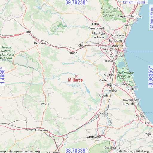
Millares GPS coordinates[2]
39° 15' 0" North, 0° 46' 0.012" West
| Map corner | latitude | longitude |
|---|---|---|
| Upper-left | 39.79238°, | -1.4698° |
| Center: | 39.25°, | -0.76667° |
| Lower-right: | 38.70339°, | -0.06355° |
| Map W x H: | 121.1×121.1 km | = 75.2×75.2mi |
| max Lat: | 43.74134° ⇑79% North |
| Millares: | 39.25° |
| min Lat: | ⇓21% South 27.64134° |
| min Long | Millares | max Long |
| -18.00367° | -0.76667° | 4.2899° |
| W 79.2%⇐ | ⇒20.8% E |
Elevation
Elevation of Millares is 128 m = 420 ft, and this is 470 m = 1542 ft below average elevation for this country.
| Max E: |
1682 m = 5518 ft | 85.7% |
| Avg. | 598 m = 1962 ft | |
| Millares | 128 m = 420 ft | |
Min E: |
0 m = 0 ft | 14.3% |
See also: Spain elevation on elevation.city.
Geographical zone
Millares is located in North temperate zone (between Tropic of Cancer and the Arctic Circle). Distance of this Northern Tropic circle is 1758.3 km =1092.6 mi to South.| Distance of | km | miles | from Millares |
|---|---|---|---|
| North Pole | 5642.9 | 3506.3 | to North |
| Arctic Circle | 3037 | 1887.1 | to North |
| Tropic Cancer | 1758.3 | 1092.6 | to South |
| Equator | 4364.2 | 2711.8 | to South |


Nearby cities:
15 places around Millares: (largest is in red/bold)
• Alborache
14.8 km =9.2 mi,  0°
0°
• Alfarp
19 km =11.8 mi,  78°
78°
• Bicorp
13.2 km =8.2 mi,  187°
187°
• Buñol
18.6 km =11.6 mi,  355°
355°
• Catadau
17.3 km =10.7 mi, 83°
• Cortes de Pallás
14.4 km =8.9 mi,  270°
270°
• Dos Aguas
4.7 km =2.9 mi,  322°
322°
• Llombai
17.6 km =10.9 mi, 77°
• Macastre
14.9 km =9.3 mi,  354°
354°
• Montroy
15.9 km =9.9 mi,  54°
54°
• Navarrés
17.6 km =10.9 mi,  159°
159°
• Quesa
14.7 km =9.1 mi,  170°
170°
• Real de Montroi
17.1 km =10.6 mi,  57°
57°
• Turís
15.9 km =9.9 mi,  21°
21°
• Yátova
15.1 km =9.4 mi, 349°
Sources, notices
• [Note1] Compared only with cities in Spain existing in our database
• [Src1] Map data: © OpenStreetMap contributors (CC-BY-SA)
• [Src2] Other city data from geonames.org with taken over terms of usage.
• [Src3] Geographical zone / Annual Mean Temperature by Robert A. Rohde @ Wikipedia
