Puente de Génave geodata
Puente de Génave (Andalusia) is a seat of a third-order administrative division; located in Spain in Europe/Madrid (GMT+2) time zone. With population of 2,064 people, there are 2124 cities with bigger population in this country. Compared to other cities in Spain, 86.4% of cities are located further ↑North; 57.4% of cities are located further ←West and 58.7% of cities have higher elevation than Puente de Génave. Note1


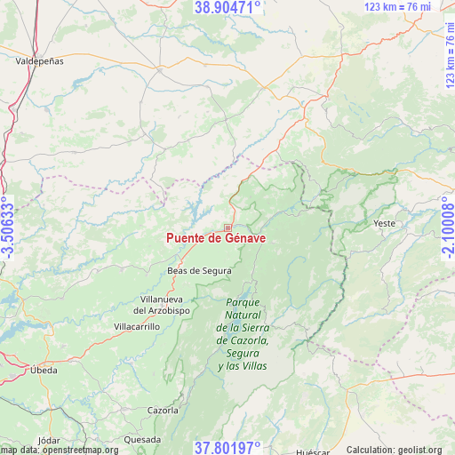
Puente de Génave GPS coordinates[2]
38° 21' 19.584" North, 2° 48' 11.52" West
| Map corner | latitude | longitude |
|---|---|---|
| Upper-left | 38.90471°, | -3.50633° |
| Center: | 38.35544°, | -2.8032° |
| Lower-right: | 37.80197°, | -2.10008° |
| Map W x H: | 122.6×122.6 km | = 76.2×76.2mi |
| max Lat: | 43.74134° ⇑86.4% North |
| Puente de Génave: | 38.35544° |
| min Lat: | ⇓13.6% South 27.64134° |
| min Long | Puente de Géna | max Long |
| -18.00367° | -2.8032° | 4.2899° |
| W 57.4%⇐ | ⇒42.6% E |
Elevation
Elevation of Puente de Génave is 544 m = 1785 ft, and this is 54 m = 177 ft below average elevation for this country.
| Max E: |
1682 m = 5518 ft | 58.7% |
| Avg. | 598 m = 1962 ft | |
| Puente de Génave | 544 m = 1785 ft | |
Min E: |
0 m = 0 ft | 41.3% |
See also: Spain elevation on elevation.city.
Geographical zone
Puente de Génave is located in North temperate zone (between Tropic of Cancer and the Arctic Circle). Distance of this Northern Tropic circle is 1658.8 km =1030.7 mi to South.| Distance of | km | miles | from Puente de Génave |
|---|---|---|---|
| North Pole | 5742.3 | 3568.1 | to North |
| Arctic Circle | 3136.4 | 1948.9 | to North |
| Tropic Cancer | 1658.8 | 1030.7 | to South |
| Equator | 4264.7 | 2650 | to South |


Nearby cities:
15 places around Puente de Génave: (largest is in red/bold)
• Arroyo del Ojanco
8.9 km =5.5 mi,  244°
244°
• Beas de Segura
13.7 km =8.5 mi,  213°
213°
• Benatae
13.3 km =8.3 mi,  91°
91°
• Bienservida
24.6 km =15.3 mi,  42°
42°
• Campiña
21.7 km =13.5 mi,  225°
225°
• Chiclana de Segura
21.4 km =13.3 mi,  256°
256°
• Génave
10.4 km =6.5 mi, 36°
• La Puerta de Segura
5.6 km =3.5 mi, 92°
• Montizón
26.3 km =16.3 mi,  266°
266°
• Orcera
12.8 km =8 mi,  109°
109°
• Puebla del Príncipe
25.9 km =16.1 mi,  335°
335°
• Segura de la Sierra
14.6 km =9.1 mi,  115°
115°
• Siles
19.7 km =12.2 mi,  78°
78°
• Sorihuela del Guadalimar
25.3 km =15.7 mi, 239°
• Torres de Albanchez
12.8 km =8 mi,  58°
58°
Sources, notices
• [Note1] Compared only with cities in Spain existing in our database
• [Src1] Map data: © OpenStreetMap contributors (CC-BY-SA)
• [Src2] Other city data from geonames.org with taken over terms of usage.
• [Src3] Geographical zone / Annual Mean Temperature by Robert A. Rohde @ Wikipedia
