Montizón geodata
Montizón (Andalusia) is a seat of a third-order administrative division; located in Spain in Europe/Madrid (GMT+2) time zone. With population of 2,001 people, there are 2166 cities with bigger population in this country. Compared to other cities in Spain, 86.5% of cities are located further ↑North; 52.6% of cities are located further ←West and 51.5% of cities have higher elevation than Montizón. Note1


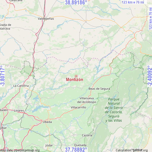
Montizón GPS coordinates[2]
38° 20' 32.964" North, 3° 6' 14.544" West
| Map corner | latitude | longitude |
|---|---|---|
| Upper-left | 38.89186°, | -3.80717° |
| Center: | 38.34249°, | -3.10404° |
| Lower-right: | 37.78892°, | -2.40092° |
| Map W x H: | 122.6×122.6 km | = 76.2×76.2mi |
| max Lat: | 43.74134° ⇑86.5% North |
| Montizón: | 38.34249° |
| min Lat: | ⇓13.5% South 27.64134° |
| min Long | Montizón | max Long |
| -18.00367° | -3.10404° | 4.2899° |
| W 52.6%⇐ | ⇒47.4% E |
Elevation
Elevation of Montizón is 643 m = 2110 ft, and this is 45 m = 148 ft above average elevation for this country.
| Max E: |
1682 m = 5518 ft | 51.5% |
| Montizón | 643 m 2110 ft | |
| Avg. | 598 m = 1962 ft | |
Min E: |
0 m = 0 ft | 48.5% |
See also: Spain elevation on elevation.city.
Geographical zone
Montizón is located in North temperate zone (between Tropic of Cancer and the Arctic Circle). Distance of this Northern Tropic circle is 1657.4 km =1029.9 mi to South.| Distance of | km | miles | from Montizón |
|---|---|---|---|
| North Pole | 5743.8 | 3569 | to North |
| Arctic Circle | 3137.9 | 1949.8 | to North |
| Tropic Cancer | 1657.4 | 1029.9 | to South |
| Equator | 4263.3 | 2649.1 | to South |


Nearby cities:
15 places around Montizón: (largest is in red/bold)
• Aldeaquemada
24.6 km =15.3 mi,  288°
288°
• Arroyo del Ojanco
18.4 km =11.4 mi,  97°
97°
• Beas de Segura
21.3 km =13.2 mi,  118°
118°
• Benatae
17.3 km =10.7 mi,  189°
189°
• Campiña
17.5 km =10.9 mi,  141°
141°
• Castellar de Santisteban
10.1 km =6.3 mi, 193°
• Chiclana de Segura
6.4 km =4 mi, 122°
• Iznatoraf
21.5 km =13.4 mi,  163°
163°
• Navas de San Juan
25.6 km =15.9 mi,  226°
226°
• Puente de Génave
26.3 km =16.3 mi,  86°
86°
• Santisteban del Puerto
13.8 km =8.6 mi,  220°
220°
• Sorihuela del Guadalimar
12.2 km =7.6 mi, 158°
• Villacarrillo
25.3 km =15.7 mi,  176°
176°
• Villamanrique
24.5 km =15.2 mi,  22°
22°
• Villanueva del Arzobispo
21.1 km =13.1 mi, 156°
Sources, notices
• [Note1] Compared only with cities in Spain existing in our database
• [Src1] Map data: © OpenStreetMap contributors (CC-BY-SA)
• [Src2] Other city data from geonames.org with taken over terms of usage.
• [Src3] Geographical zone / Annual Mean Temperature by Robert A. Rohde @ Wikipedia
