Campiña geodata
Campiña (Andalusia) is a populated place; located in Spain in Europe/Madrid (GMT+2) time zone. With population of 67,904 people, there are 135 cities with bigger population in this country. Compared to other cities in Spain, 87.1% of cities are located further ↑North; 54.9% of cities are located further ←West and 51.7% of cities have higher elevation than Campiña. Note1
Administrative division(s):
- Level 1: Andalusia
- Level 2: Provincia de Jaén
- Level 3: Sorihuela del Guadalimar


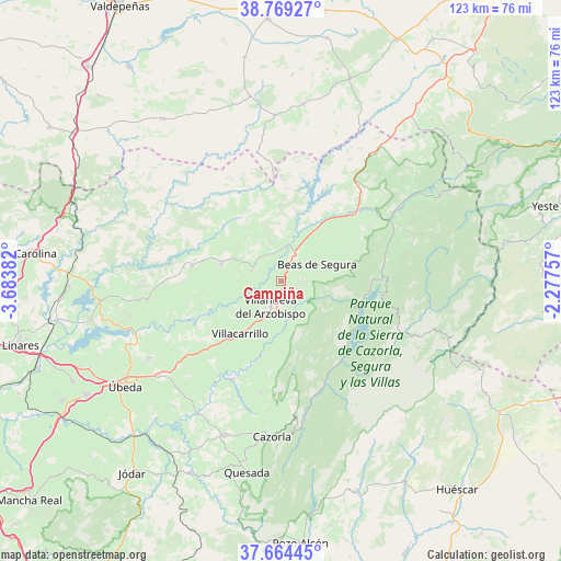
Campiña GPS coordinates[2]
38° 13' 8.256" North, 2° 58' 50.484" West
| Map corner | latitude | longitude |
|---|---|---|
| Upper-left | 38.76927°, | -3.68382° |
| Center: | 38.21896°, | -2.98069° |
| Lower-right: | 37.66445°, | -2.27757° |
| Map W x H: | 122.8×122.8 km | = 76.3×76.3mi |
| max Lat: | 43.74134° ⇑87.1% North |
| Campiña: | 38.21896° |
| min Lat: | ⇓12.9% South 27.64134° |
| min Long | Campiña | max Long |
| -18.00367° | -2.98069° | 4.2899° |
| W 54.9%⇐ | ⇒45.1% E |
Elevation
Elevation of Campiña is 641 m = 2103 ft, and this is 43 m = 141 ft above average elevation for this country.
| Max E: |
1682 m = 5518 ft | 51.7% |
| Campiña | 641 m 2103 ft | |
| Avg. | 598 m = 1962 ft | |
Min E: |
0 m = 0 ft | 48.3% |
See also: Campiña elevation on elevation.city.
Geographical zone
Campiña is located in North temperate zone (between Tropic of Cancer and the Arctic Circle). Distance of this Northern Tropic circle is 1643.6 km =1021.3 mi to South.| Distance of | km | miles | from Campiña |
|---|---|---|---|
| North Pole | 5757.5 | 3577.5 | to North |
| Arctic Circle | 3151.6 | 1958.3 | to North |
| Tropic Cancer | 1643.6 | 1021.3 | to South |
| Equator | 4249.5 | 2640.5 | to South |


Nearby cities:
15 places around Campiña: (largest is in red/bold)
• Arroyo del Ojanco
13.6 km =8.5 mi,  33°
33°
• Beas de Segura
8.8 km =5.5 mi,  65°
65°
• Benatae
13.9 km =8.6 mi,  256°
256°
• Castellar de Santisteban
13.8 km =8.6 mi,  286°
286°
• Chiclana de Segura
11.6 km =7.2 mi,  332°
332°
• Chilluévar
24.7 km =15.3 mi,  190°
190°
• Iznatoraf
8.2 km =5.1 mi,  213°
213°
• La Puerta de Segura
25.8 km =16 mi,  54°
54°
• Montizón
17.5 km =10.9 mi,  321°
321°
• Puente de Génave
21.7 km =13.5 mi, 45°
• Santisteban del Puerto
20.1 km =12.5 mi,  279°
279°
• Santo Tomé
23.6 km =14.7 mi, 206°
• Sorihuela del Guadalimar
6.8 km =4.2 mi, 290°
• Villacarrillo
14.7 km =9.1 mi,  218°
218°
• Villanueva del Arzobispo
6.1 km =3.8 mi,  202°
202°
Sources, notices
• [Note1] Compared only with cities in Spain existing in our database
• [Src1] Map data: © OpenStreetMap contributors (CC-BY-SA)
• [Src2] Other city data from geonames.org with taken over terms of usage.
• [Src3] Geographical zone / Annual Mean Temperature by Robert A. Rohde @ Wikipedia
