Orcera geodata
Orcera (Andalusia) is a seat of a third-order administrative division; located in Spain in Europe/Madrid (GMT+2) time zone. With population of 2,116 people, there are 2092 cities with bigger population in this country. Compared to other cities in Spain, 86.7% of cities are located further ↑North; 59% of cities are located further ←West and 62.3% of cities have lower elevation than Orcera. Note1


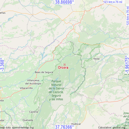
Orcera GPS coordinates[2]
38° 19' 2.712" North, 2° 39' 53.532" West
| Map corner | latitude | longitude |
|---|---|---|
| Upper-left | 38.86698°, | -3.368° |
| Center: | 38.31742°, | -2.66487° |
| Lower-right: | 37.76366°, | -1.96175° |
| Map W x H: | 122.7×122.7 km | = 76.2×76.2mi |
| max Lat: | 43.74134° ⇑86.7% North |
| Orcera: | 38.31742° |
| min Lat: | ⇓13.3% South 27.64134° |
| min Long | Orcera | max Long |
| -18.00367° | -2.66487° | 4.2899° |
| W 59%⇐ | ⇒41% E |
Elevation
Elevation of Orcera is 759 m = 2490 ft, and this is 161 m = 528 ft above average elevation for this country.
| Max E: |
1682 m = 5518 ft | 37.7% |
| Orcera | 759 m 2490 ft | |
| Avg. | 598 m = 1962 ft | |
Min E: |
0 m = 0 ft | 62.3% |
See also: Spain elevation on elevation.city.
Geographical zone
Orcera is located in North temperate zone (between Tropic of Cancer and the Arctic Circle). Distance of this Northern Tropic circle is 1654.6 km =1028.1 mi to South.| Distance of | km | miles | from Orcera |
|---|---|---|---|
| North Pole | 5746.6 | 3570.8 | to North |
| Arctic Circle | 3140.7 | 1951.5 | to North |
| Tropic Cancer | 1654.6 | 1028.1 | to South |
| Equator | 4260.5 | 2647.4 | to South |


Nearby cities:
15 places around Orcera: (largest is in red/bold)
• Arroyo del Ojanco
20.1 km =12.5 mi,  271°
271°
• Beas de Segura
20.8 km =12.9 mi,  249°
249°
• Benatae
4.2 km =2.6 mi,  16°
16°
• Bienservida
22.7 km =14.1 mi,  11°
11°
• Campiña
29.7 km =18.5 mi, 248°
• Cotillas
18.8 km =11.7 mi,  47°
47°
• Génave
13.9 km =8.6 mi,  334°
334°
• La Puerta de Segura
7.6 km =4.7 mi,  301°
301°
• Puente de Génave
12.8 km =8 mi,  289°
289°
• Riópar
27.6 km =17.1 mi,  42°
42°
• Segura de la Sierra
2.4 km =1.5 mi,  153°
153°
• Siles
10.8 km =6.7 mi, 41°
• Torres de Albanchez
11 km =6.8 mi,  354°
354°
• Villapalacios
28.8 km =17.9 mi, 5°
• Villaverde de Guadalimar
20 km =12.4 mi, 39°
Sources, notices
• [Note1] Compared only with cities in Spain existing in our database
• [Src1] Map data: © OpenStreetMap contributors (CC-BY-SA)
• [Src2] Other city data from geonames.org with taken over terms of usage.
• [Src3] Geographical zone / Annual Mean Temperature by Robert A. Rohde @ Wikipedia
