Segura de la Sierra geodata
Segura de la Sierra (Andalusia) is a populated place; located in Spain in Europe/Madrid (GMT+2) time zone. With population of 1,773 people, there are 2304 cities with bigger population in this country. Compared to other cities in Spain, 86.8% of cities are located further ↑North; 59.2% of cities are located further ←West and 92.2% of cities have lower elevation than Segura de la Sierra. Note1


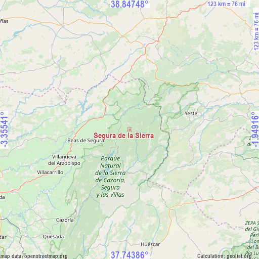
Segura de la Sierra GPS coordinates[2]
38° 17' 51.972" North, 2° 39' 8.244" West
| Map corner | latitude | longitude |
|---|---|---|
| Upper-left | 38.84748°, | -3.35541° |
| Center: | 38.29777°, | -2.65229° |
| Lower-right: | 37.74386°, | -1.94916° |
| Map W x H: | 122.7×122.7 km | = 76.2×76.2mi |
| max Lat: | 43.74134° ⇑86.8% North |
| Segura de la Sierra: | 38.29777° |
| min Lat: | ⇓13.2% South 27.64134° |
| min Long | Segura de la Si | max Long |
| -18.00367° | -2.65229° | 4.2899° |
| W 59.2%⇐ | ⇒40.8% E |
Elevation
Elevation of Segura de la Sierra is 1071 m = 3514 ft, and this is 473 m = 1552 ft above average elevation for this country.
| Max E: |
1682 m = 5518 ft | 7.8% |
| Segura de la Sierra | 1071 m 3514 ft | |
| Avg. | 598 m = 1962 ft | |
Min E: |
0 m = 0 ft | 92.2% |
See also: Spain elevation on elevation.city.
Geographical zone
Segura de la Sierra is located in North temperate zone (between Tropic of Cancer and the Arctic Circle). Distance of this Northern Tropic circle is 1652.4 km =1026.8 mi to South.| Distance of | km | miles | from Segura de la Sierra |
|---|---|---|---|
| North Pole | 5748.7 | 3572.1 | to North |
| Arctic Circle | 3142.9 | 1952.9 | to North |
| Tropic Cancer | 1652.4 | 1026.8 | to South |
| Equator | 4258.3 | 2646 | to South |


Nearby cities:
15 places around Segura de la Sierra: (largest is in red/bold)
• Arroyo del Ojanco
21.3 km =13.2 mi,  276°
276°
• Beas de Segura
21.2 km =13.2 mi,  256°
256°
• Benatae
6.2 km =3.9 mi,  0°
0°
• Bienservida
24.7 km =15.3 mi,  8°
8°
• Campiña
30 km =18.6 mi,  253°
253°
• Cotillas
19.6 km =12.2 mi,  40°
40°
• Génave
16.4 km =10.2 mi,  334°
334°
• La Puerta de Segura
9.8 km =6.1 mi,  308°
308°
• Orcera
2.4 km =1.5 mi, 333°
• Puente de Génave
14.6 km =9.1 mi,  295°
295°
• Riópar
28.6 km =17.8 mi, 38°
• Siles
11.9 km =7.4 mi,  30°
30°
• Torres de Albanchez
13.3 km =8.3 mi,  350°
350°
• Villaverde de Guadalimar
21.1 km =13.1 mi, 33°
• Yeste
30.2 km =18.8 mi,  74°
74°
Sources, notices
• [Note1] Compared only with cities in Spain existing in our database
• [Src1] Map data: © OpenStreetMap contributors (CC-BY-SA)
• [Src2] Other city data from geonames.org with taken over terms of usage.
• [Src3] Geographical zone / Annual Mean Temperature by Robert A. Rohde @ Wikipedia
