Olocau geodata
Olocau (Valencia) is a populated place; located in Spain in Europe/Madrid (GMT+2) time zone. With population of 1,127 people, there are 2796 cities with bigger population in this country. Compared to other cities in Spain, 74.5% of cities are located further ↑North; 81.3% of cities are located further ←West and 77.2% of cities have higher elevation than Olocau. Note1


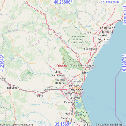
Olocau GPS coordinates[2]
39° 42' 0" North, 0° 31' 59.988" West
| Map corner | latitude | longitude |
|---|---|---|
| Upper-left | 40.23886°, | -1.23646° |
| Center: | 39.7°, | -0.53333° |
| Lower-right: | 39.1569°, | 0.16979° |
| Map W x H: | 120.3×120.3 km | = 74.8×74.8mi |
| max Lat: | 43.74134° ⇑74.5% North |
| Olocau: | 39.7° |
| min Lat: | ⇓25.5% South 27.64134° |
| min Long | Olocau | max Long |
| -18.00367° | -0.53333° | 4.2899° |
| W 81.3%⇐ | ⇒18.7% E |
Elevation
Elevation of Olocau is 267 m = 876 ft, and this is 331 m = 1086 ft below average elevation for this country.
| Max E: |
1682 m = 5518 ft | 77.2% |
| Avg. | 598 m = 1962 ft | |
| Olocau | 267 m = 876 ft | |
Min E: |
0 m = 0 ft | 22.8% |
See also: Spain elevation on elevation.city.
Geographical zone
Olocau is located in North temperate zone (between Tropic of Cancer and the Arctic Circle). Distance of this Northern Tropic circle is 1808.3 km =1123.6 mi to South.| Distance of | km | miles | from Olocau |
|---|---|---|---|
| North Pole | 5592.8 | 3475.2 | to North |
| Arctic Circle | 2986.9 | 1856 | to North |
| Tropic Cancer | 1808.3 | 1123.6 | to South |
| Equator | 4414.2 | 2742.9 | to South |


Nearby cities:
15 places around Olocau: (largest is in red/bold)
• Algimia de Alfara
15.3 km =9.5 mi,  68°
68°
• Benaguasil
11.9 km =7.4 mi,  201°
201°
• Benisanó
9.7 km =6 mi, 197°
• Bétera
13.6 km =8.5 mi,  153°
153°
• Casinos
14.3 km =8.9 mi,  270°
270°
• Domeño
12.5 km =7.8 mi,  249°
249°
• Estivella
15.8 km =9.8 mi,  83°
83°
• Geldo
15.9 km =9.9 mi,  21°
21°
• L'Eliana
14.8 km =9.2 mi,  180°
180°
• La Pobla de Vallbona
11.5 km =7.1 mi,  189°
189°
• Llíria
9.6 km =6 mi,  214°
214°
• Marines
4.6 km =2.9 mi,  2°
2°
• Náquera
11.4 km =7.1 mi,  119°
119°
• Segart
14.4 km =8.9 mi,  97°
97°
• Serra
8.8 km =5.5 mi, 102°
Sources, notices
• [Note1] Compared only with cities in Spain existing in our database
• [Src1] Map data: © OpenStreetMap contributors (CC-BY-SA)
• [Src2] Other city data from geonames.org with taken over terms of usage.
• [Src3] Geographical zone / Annual Mean Temperature by Robert A. Rohde @ Wikipedia
