Espiel geodata
Espiel (Andalusia) is a seat of a third-order administrative division; located in Spain in Europe/Madrid (GMT+2) time zone. With population of 2,332 people, there are 1984 cities with bigger population in this country. Compared to other cities in Spain, 87.2% of cities are located further ↑North; 72.7% of cities are located further →East and 55.9% of cities have lower elevation than Espiel. Note1


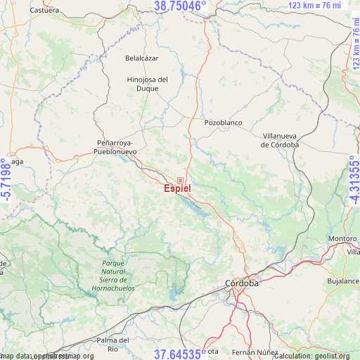
Espiel GPS coordinates[2]
38° 12' 0" North, 5° 1' 0.012" West
| Map corner | latitude | longitude |
|---|---|---|
| Upper-left | 38.75046°, | -5.7198° |
| Center: | 38.2°, | -5.01667° |
| Lower-right: | 37.64535°, | -4.31355° |
| Map W x H: | 122.9×122.9 km | = 76.4×76.4mi |
| max Lat: | 43.74134° ⇑87.2% North |
| Espiel: | 38.2° |
| min Lat: | ⇓12.8% South 27.64134° |
| min Long | Espiel | max Long |
| -18.00367° | -5.01667° | 4.2899° |
| W 27.3%⇐ | ⇒72.7% E |
Elevation
Elevation of Espiel is 715 m = 2346 ft, and this is 117 m = 384 ft above average elevation for this country.
| Max E: |
1682 m = 5518 ft | 44.1% |
| Espiel | 715 m 2346 ft | |
| Avg. | 598 m = 1962 ft | |
Min E: |
0 m = 0 ft | 55.9% |
See also: Spain elevation on elevation.city.
Geographical zone
Espiel is located in North temperate zone (between Tropic of Cancer and the Arctic Circle). Distance of this Northern Tropic circle is 1641.5 km =1020 mi to South.| Distance of | km | miles | from Espiel |
|---|---|---|---|
| North Pole | 5759.6 | 3578.8 | to North |
| Arctic Circle | 3153.7 | 1959.6 | to North |
| Tropic Cancer | 1641.5 | 1020 | to South |
| Equator | 4247.4 | 2639.2 | to South |


Nearby cities:
15 places around Espiel: (largest is in red/bold)
• Alcaracejos
20.8 km =12.9 mi,  12°
12°
• Añora
26.2 km =16.3 mi,  22°
22°
• Bélmez
17.6 km =10.9 mi,  294°
294°
• Dos Torres
29.6 km =18.4 mi, 20°
• El Viso
32 km =19.9 mi, 10°
• Fuente la Lancha
24.1 km =15 mi,  356°
356°
• Hinojosa del Duque
35.3 km =21.9 mi,  341°
341°
• Obejo
20.4 km =12.7 mi,  111°
111°
• Pedroche
33.7 km =20.9 mi,  41°
41°
• Peñarroya-Pueblonuevo
24.5 km =15.2 mi,  296°
296°
• Pozoblanco
24.7 km =15.3 mi, 36°
• Villaharta
12.6 km =7.8 mi,  126°
126°
• Villanueva del Duque
20.4 km =12.7 mi,  4°
4°
• Villaralto
27.9 km =17.3 mi, 5°
• Villaviciosa de Córdoba
13 km =8.1 mi,  180°
180°
Sources, notices
• [Note1] Compared only with cities in Spain existing in our database
• [Src1] Map data: © OpenStreetMap contributors (CC-BY-SA)
• [Src2] Other city data from geonames.org with taken over terms of usage.
• [Src3] Geographical zone / Annual Mean Temperature by Robert A. Rohde @ Wikipedia
