Son Servera geodata
Son Servera (Balearic Islands) is a seat of a third-order administrative division; located in Spain in Europe/Madrid (GMT+2) time zone. With population of 12,215 people, there are 741 cities with bigger population in this country. Compared to other cities in Spain, 75.4% of cities are located further ↑North; 99.9% of cities are located further ←West and 88.9% of cities have higher elevation than Son Servera. Note1


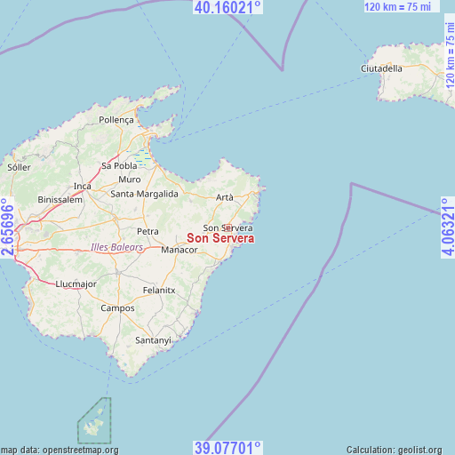
Son Servera GPS coordinates[2]
39° 37' 14.628" North, 3° 21' 36.288" East
| Map corner | latitude | longitude |
|---|---|---|
| Upper-left | 40.16021°, | 2.65696° |
| Center: | 39.62073°, | 3.36008° |
| Lower-right: | 39.07701°, | 4.06321° |
| Map W x H: | 120.4×120.4 km | = 74.8×74.8mi |
| max Lat: | 43.74134° ⇑75.4% North |
| Son Servera: | 39.62073° |
| min Lat: | ⇓24.6% South 27.64134° |
| min Long | Son Servera | max Long |
| -18.00367° | 3.36008° | 4.2899° |
| W 99.9%⇐ | ⇒0.099999999999994% E |
Elevation
Elevation of Son Servera is 82 m = 269 ft, and this is 516 m = 1693 ft below average elevation for this country.
| Max E: |
1682 m = 5518 ft | 88.9% |
| Avg. | 598 m = 1962 ft | |
| Son Servera | 82 m = 269 ft | |
Min E: |
0 m = 0 ft | 11.1% |
See also: Spain elevation on elevation.city.
Geographical zone
Son Servera is located in North temperate zone (between Tropic of Cancer and the Arctic Circle). Distance of this Northern Tropic circle is 1799.5 km =1118.2 mi to South.| Distance of | km | miles | from Son Servera |
|---|---|---|---|
| North Pole | 5601.6 | 3480.7 | to North |
| Arctic Circle | 2995.8 | 1861.5 | to North |
| Tropic Cancer | 1799.5 | 1118.2 | to South |
| Equator | 4405.4 | 2737.4 | to South |


Nearby cities:
15 places around Son Servera: (largest is in red/bold)
• Ariany
21.6 km =13.4 mi,  278°
278°
• Artà
8.1 km =5 mi,  353°
353°
• Cala Rajada
13.4 km =8.3 mi,  41°
41°
• Can Picafort
23.8 km =14.8 mi,  312°
312°
• Capdepera
11.1 km =6.9 mi, 35°
• Felanitx
24.7 km =15.3 mi,  227°
227°
• Manacor
14.1 km =8.8 mi,  246°
246°
• Maria de la Salut
25 km =15.5 mi, 280°
• Petra
21.2 km =13.2 mi,  267°
267°
• Porto Cristo
9.3 km =5.8 mi,  194°
194°
• Portocolom
24.4 km =15.2 mi,  201°
201°
• Sant Joan
27.6 km =17.1 mi,  264°
264°
• Sant Llorenç des Cardassar
6.6 km =4.1 mi, 259°
• Santa Margalida
23.8 km =14.8 mi,  292°
292°
• Vilafranca de Bonany
24 km =14.9 mi, 256°
Sources, notices
• [Note1] Compared only with cities in Spain existing in our database
• [Src1] Map data: © OpenStreetMap contributors (CC-BY-SA)
• [Src2] Other city data from geonames.org with taken over terms of usage.
• [Src3] Geographical zone / Annual Mean Temperature by Robert A. Rohde @ Wikipedia
