Altea geodata
Altea (Valencia) is a seat of a third-order administrative division; located in Spain in Europe/Madrid (GMT+2) time zone. With population of 23,780 people, there are 393 cities with bigger population in this country. Compared to other cities in Spain, 85% of cities are located further ↑North; 86.7% of cities are located further ←West and 90.6% of cities have higher elevation than Altea. Note1


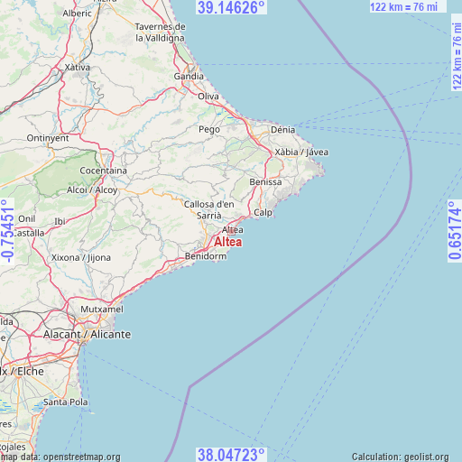
Altea GPS coordinates[2]
38° 35' 55.86" North, 0° 3' 5.004" West
| Map corner | latitude | longitude |
|---|---|---|
| Upper-left | 39.14626°, | -0.75451° |
| Center: | 38.59885°, | -0.05139° |
| Lower-right: | 38.04723°, | 0.65174° |
| Map W x H: | 122.2×122.2 km | = 75.9×75.9mi |
| max Lat: | 43.74134° ⇑85% North |
| Altea: | 38.59885° |
| min Lat: | ⇓15% South 27.64134° |
| min Long | Altea | max Long |
| -18.00367° | -0.05139° | 4.2899° |
| W 86.7%⇐ | ⇒13.3% E |
Elevation
Elevation of Altea is 56 m = 184 ft, and this is 542 m = 1778 ft below average elevation for this country.
| Max E: |
1682 m = 5518 ft | 90.6% |
| Avg. | 598 m = 1962 ft | |
| Altea | 56 m = 184 ft | |
Min E: |
0 m = 0 ft | 9.4% |
See also: Spain elevation on elevation.city.
Geographical zone
Altea is located in North temperate zone (between Tropic of Cancer and the Arctic Circle). Distance of this Northern Tropic circle is 1685.9 km =1047.6 mi to South.| Distance of | km | miles | from Altea |
|---|---|---|---|
| North Pole | 5715.3 | 3551.3 | to North |
| Arctic Circle | 3109.4 | 1932.1 | to North |
| Tropic Cancer | 1685.9 | 1047.6 | to South |
| Equator | 4291.8 | 2666.8 | to South |


Nearby cities:
15 places around Altea: (largest is in red/bold)
• Alcalalí
16.9 km =10.5 mi,  3°
3°
• Benidorm
9.7 km =6 mi,  225°
225°
• Benimantell
16.3 km =10.1 mi,  302°
302°
• Benissa
15.5 km =9.6 mi,  33°
33°
• Bolulla
10 km =6.2 mi,  328°
328°
• Callosa d'En Sarrià
8 km =5 mi,  315°
315°
• Calp
9.8 km =6.1 mi,  58°
58°
• Finestrat
14.4 km =8.9 mi,  255°
255°
• Jalón
16.1 km =10 mi,  12°
12°
• Parcent
16.3 km =10.1 mi,  356°
356°
• Polop
7.4 km =4.6 mi,  290°
290°
• Senija
16.5 km =10.3 mi, 29°
• Tárbena
11.5 km =7.1 mi,  337°
337°
• l'Alfàs del Pi
4.9 km =3 mi,  245°
245°
• la Nucia
6.8 km =4.2 mi,  284°
284°
Sources, notices
• [Note1] Compared only with cities in Spain existing in our database
• [Src1] Map data: © OpenStreetMap contributors (CC-BY-SA)
• [Src2] Other city data from geonames.org with taken over terms of usage.
• [Src3] Geographical zone / Annual Mean Temperature by Robert A. Rohde @ Wikipedia
