Bullas geodata
Bullas (Murcia) is a seat of a third-order administrative division; located in Spain in Europe/Madrid (GMT+2) time zone. With population of 12,493 people, there are 728 cities with bigger population in this country. Compared to other cities in Spain, 88.2% of cities are located further ↑North; 71.1% of cities are located further ←West and 50.4% of cities have higher elevation than Bullas. Note1


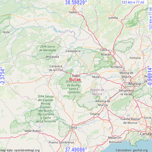
Bullas GPS coordinates[2]
38° 2' 48.012" North, 1° 40' 20.172" West
| Map corner | latitude | longitude |
|---|---|---|
| Upper-left | 38.59829°, | -2.3754° |
| Center: | 38.04667°, | -1.67227° |
| Lower-right: | 37.49086°, | -0.96914° |
| Map W x H: | 123.1×123.1 km | = 76.5×76.5mi |
| max Lat: | 43.74134° ⇑88.2% North |
| Bullas: | 38.04667° |
| min Lat: | ⇓11.8% South 27.64134° |
| min Long | Bullas | max Long |
| -18.00367° | -1.67227° | 4.2899° |
| W 71.1%⇐ | ⇒28.9% E |
Elevation
Elevation of Bullas is 654 m = 2146 ft, and this is 56 m = 184 ft above average elevation for this country.
| Max E: |
1682 m = 5518 ft | 50.4% |
| Bullas | 654 m 2146 ft | |
| Avg. | 598 m = 1962 ft | |
Min E: |
0 m = 0 ft | 49.6% |
See also: Spain elevation on elevation.city.
Geographical zone
Bullas is located in North temperate zone (between Tropic of Cancer and the Arctic Circle). Distance of this Northern Tropic circle is 1624.5 km =1009.4 mi to South.| Distance of | km | miles | from Bullas |
|---|---|---|---|
| North Pole | 5776.7 | 3589.5 | to North |
| Arctic Circle | 3170.8 | 1970.2 | to North |
| Tropic Cancer | 1624.5 | 1009.4 | to South |
| Equator | 4230.4 | 2628.6 | to South |


Nearby cities:
15 places around Bullas: (largest is in red/bold)
• Abarán
29.7 km =18.5 mi,  53°
53°
• Albudeite
25.1 km =15.6 mi,  94°
94°
• Aledo
29.5 km =18.3 mi,  162°
162°
• Alhama de Murcia
30.7 km =19.1 mi,  135°
135°
• Blanca
29.9 km =18.6 mi,  60°
60°
• Calasparra
20.5 km =12.7 mi,  353°
353°
• Campos del Río
28 km =17.4 mi, 91°
• Caravaca
18 km =11.2 mi,  291°
291°
• Cehegín
12.2 km =7.6 mi, 294°
• Cieza
30.8 km =19.1 mi, 45°
• Moratalla
24.9 km =15.5 mi,  309°
309°
• Mula
16 km =9.9 mi, 92°
• Ojós
30.9 km =19.2 mi,  68°
68°
• Pliego
16 km =9.9 mi,  113°
113°
• Ricote
29.3 km =18.2 mi, 66°
Sources, notices
• [Note1] Compared only with cities in Spain existing in our database
• [Src1] Map data: © OpenStreetMap contributors (CC-BY-SA)
• [Src2] Other city data from geonames.org with taken over terms of usage.
• [Src3] Geographical zone / Annual Mean Temperature by Robert A. Rohde @ Wikipedia
