Mollina geodata
Mollina (Andalusia) is a seat of a third-order administrative division; located in Spain in Europe/Madrid (GMT+2) time zone. With population of 4,082 people, there are 1456 cities with bigger population in this country. Compared to other cities in Spain, 94.7% of cities are located further ↑North; 68.1% of cities are located further →East and 63.9% of cities have higher elevation than Mollina. Note1


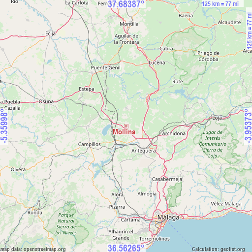
Mollina GPS coordinates[2]
37° 7' 31.224" North, 4° 39' 24.696" West
| Map corner | latitude | longitude |
|---|---|---|
| Upper-left | 37.68387°, | -5.35998° |
| Center: | 37.12534°, | -4.65686° |
| Lower-right: | 36.56265°, | -3.95373° |
| Map W x H: | 124.7×124.7 km | = 77.5×77.5mi |
| max Lat: | 43.74134° ⇑94.7% North |
| Mollina: | 37.12534° |
| min Lat: | ⇓5.3% South 27.64134° |
| min Long | Mollina | max Long |
| -18.00367° | -4.65686° | 4.2899° |
| W 31.9%⇐ | ⇒68.1% E |
Elevation
Elevation of Mollina is 475 m = 1558 ft, and this is 123 m = 404 ft below average elevation for this country.
| Max E: |
1682 m = 5518 ft | 63.9% |
| Avg. | 598 m = 1962 ft | |
| Mollina | 475 m = 1558 ft | |
Min E: |
0 m = 0 ft | 36.1% |
See also: Spain elevation on elevation.city.
Geographical zone
Mollina is located in North temperate zone (between Tropic of Cancer and the Arctic Circle). Distance of this Northern Tropic circle is 1522 km =945.7 mi to South.| Distance of | km | miles | from Mollina |
|---|---|---|---|
| North Pole | 5879.1 | 3653.1 | to North |
| Arctic Circle | 3273.2 | 2033.9 | to North |
| Tropic Cancer | 1522 | 945.7 | to South |
| Equator | 4128 | 2565 | to South |


Nearby cities:
15 places around Mollina: (largest is in red/bold)
• Alameda
9.3 km =5.8 mi,  359°
359°
• Antequera
14.5 km =9 mi,  144°
144°
• Badolatosa
20.3 km =12.6 mi, 355°
• Benamejí
18.9 km =11.7 mi,  32°
32°
• Campillos
20.2 km =12.6 mi,  244°
244°
• Casariche
20.8 km =12.9 mi,  334°
334°
• Cuevas Bajas
19.4 km =12.1 mi,  50°
50°
• Encinas Reales
22.3 km =13.9 mi,  42°
42°
• Fuente de Piedra
6.6 km =4.1 mi,  279°
279°
• Humilladero
4.3 km =2.7 mi,  252°
252°
• La Roda de Andalucía
13.8 km =8.6 mi,  309°
309°
• Lora de Estepa
22 km =13.7 mi,  316°
316°
• Palenciana
15.2 km =9.4 mi, 25°
• Sierra de Yeguas
18.7 km =11.6 mi,  269°
269°
• Villanueva de Algaidas
19.4 km =12.1 mi,  70°
70°
Sources, notices
• [Note1] Compared only with cities in Spain existing in our database
• [Src1] Map data: © OpenStreetMap contributors (CC-BY-SA)
• [Src2] Other city data from geonames.org with taken over terms of usage.
• [Src3] Geographical zone / Annual Mean Temperature by Robert A. Rohde @ Wikipedia
