La Roda de Andalucía geodata
La Roda de Andalucía (Andalusia) is a populated place; located in Spain in Europe/Madrid (GMT+2) time zone. With population of 4,294 people, there are 1421 cities with bigger population in this country. Compared to other cities in Spain, 94% of cities are located further ↑North; 69.4% of cities are located further →East and 69.3% of cities have higher elevation than La Roda de Andalucía. Note1
Administrative division(s):
- Level 1: Andalusia
- Level 2: Provincia de Sevilla
- Level 3: Roda de Andalucía, La


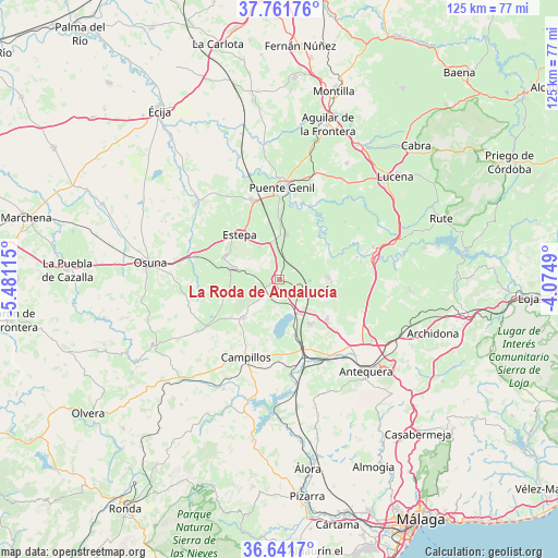
La Roda de Andalucía GPS coordinates[2]
37° 12' 13.716" North, 4° 46' 40.872" West
| Map corner | latitude | longitude |
|---|---|---|
| Upper-left | 37.76176°, | -5.48115° |
| Center: | 37.20381°, | -4.77802° |
| Lower-right: | 36.6417°, | -4.0749° |
| Map W x H: | 124.5×124.5 km | = 77.4×77.4mi |
| max Lat: | 43.74134° ⇑94% North |
| La Roda de Andalucía: | 37.20381° |
| min Lat: | ⇓6% South 27.64134° |
| min Long | La Roda de Anda | max Long |
| -18.00367° | -4.77802° | 4.2899° |
| W 30.6%⇐ | ⇒69.4% E |
Elevation
Elevation of La Roda de Andalucía is 395 m = 1296 ft, and this is 203 m = 666 ft below average elevation for this country.
| Max E: |
1682 m = 5518 ft | 69.3% |
| Avg. | 598 m = 1962 ft | |
| La Roda de Andalucía | 395 m = 1296 ft | |
Min E: |
0 m = 0 ft | 30.7% |
See also: Spain elevation on elevation.city.
Geographical zone
La Roda de Andalucía is located in North temperate zone (between Tropic of Cancer and the Arctic Circle). Distance of this Northern Tropic circle is 1530.8 km =951.2 mi to South.| Distance of | km | miles | from La Roda de Andalucía |
|---|---|---|---|
| North Pole | 5870.4 | 3647.7 | to North |
| Arctic Circle | 3264.5 | 2028.5 | to North |
| Tropic Cancer | 1530.8 | 951.2 | to South |
| Equator | 4136.7 | 2570.4 | to South |


Nearby cities:
15 places around La Roda de Andalucía: (largest is in red/bold)
• Alameda
10.6 km =6.6 mi,  87°
87°
• Badolatosa
14.8 km =9.2 mi,  38°
38°
• Campillos
18.9 km =11.7 mi,  203°
203°
• Casariche
10.1 km =6.3 mi,  9°
9°
• Estepa
13.3 km =8.3 mi,  317°
317°
• Fuente de Piedra
8.7 km =5.4 mi,  150°
150°
• Gilena
13.2 km =8.2 mi,  293°
293°
• Herrera
18.9 km =11.7 mi,  340°
340°
• Humilladero
12 km =7.5 mi, 146°
• Lora de Estepa
8.5 km =5.3 mi,  328°
328°
• Martín de la Jara
19.5 km =12.1 mi,  237°
237°
• Mollina
13.8 km =8.6 mi,  129°
129°
• Palenciana
18 km =11.2 mi,  73°
73°
• Pedrera
10.6 km =6.6 mi,  283°
283°
• Sierra de Yeguas
11.9 km =7.4 mi,  221°
221°
Sources, notices
• [Note1] Compared only with cities in Spain existing in our database
• [Src1] Map data: © OpenStreetMap contributors (CC-BY-SA)
• [Src2] Other city data from geonames.org with taken over terms of usage.
• [Src3] Geographical zone / Annual Mean Temperature by Robert A. Rohde @ Wikipedia
