Casariche geodata
Casariche (Andalusia) is a seat of a third-order administrative division; located in Spain in Europe/Madrid (GMT+2) time zone. With population of 5,389 people, there are 1235 cities with bigger population in this country. Compared to other cities in Spain, 93% of cities are located further ↑North; 69.2% of cities are located further →East and 74.5% of cities have higher elevation than Casariche. Note1


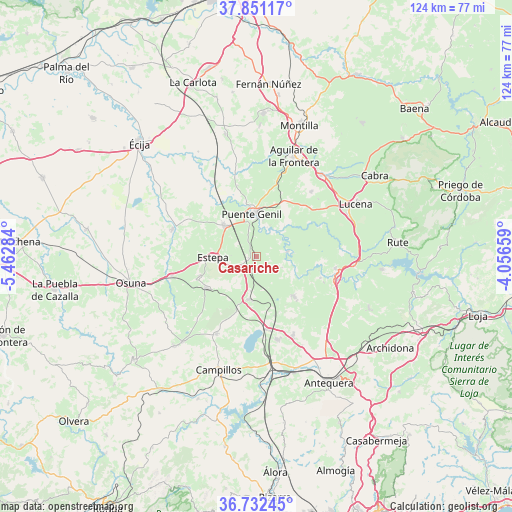
Casariche GPS coordinates[2]
37° 17' 38.004" North, 4° 45' 34.992" West
| Map corner | latitude | longitude |
|---|---|---|
| Upper-left | 37.85117°, | -5.46284° |
| Center: | 37.29389°, | -4.75972° |
| Lower-right: | 36.73245°, | -4.05659° |
| Map W x H: | 124.4×124.4 km | = 77.3×77.3mi |
| max Lat: | 43.74134° ⇑93% North |
| Casariche: | 37.29389° |
| min Lat: | ⇓7% South 27.64134° |
| min Long | Casariche | max Long |
| -18.00367° | -4.75972° | 4.2899° |
| W 30.8%⇐ | ⇒69.2% E |
Elevation
Elevation of Casariche is 305 m = 1001 ft, and this is 293 m = 961 ft below average elevation for this country.
| Max E: |
1682 m = 5518 ft | 74.5% |
| Avg. | 598 m = 1962 ft | |
| Casariche | 305 m = 1001 ft | |
Min E: |
0 m = 0 ft | 25.5% |
See also: Spain elevation on elevation.city.
Geographical zone
Casariche is located in North temperate zone (between Tropic of Cancer and the Arctic Circle). Distance of this Northern Tropic circle is 1540.8 km =957.4 mi to South.| Distance of | km | miles | from Casariche |
|---|---|---|---|
| North Pole | 5860.4 | 3641.5 | to North |
| Arctic Circle | 3254.5 | 2022.3 | to North |
| Tropic Cancer | 1540.8 | 957.4 | to South |
| Equator | 4146.7 | 2576.6 | to South |


Nearby cities:
15 places around Casariche: (largest is in red/bold)
• Alameda
13 km =8.1 mi,  136°
136°
• Badolatosa
7.8 km =4.8 mi,  78°
78°
• Benamejí
19.5 km =12.1 mi,  98°
98°
• Estepa
10.5 km =6.5 mi,  269°
269°
• Fuente de Piedra
17.8 km =11.1 mi,  171°
171°
• Gilena
14.5 km =9 mi,  250°
250°
• Herrera
11.1 km =6.9 mi,  314°
314°
• Humilladero
20.6 km =12.8 mi, 165°
• La Roda de Andalucía
10.1 km =6.3 mi,  189°
189°
• Lora de Estepa
6.6 km =4.1 mi, 245°
• Marinaleda
19.6 km =12.2 mi,  295°
295°
• Moriles
20.8 km =12.9 mi,  40°
40°
• Palenciana
16.5 km =10.3 mi,  107°
107°
• Pedrera
14.1 km =8.8 mi,  237°
237°
• Puente-Genil
10.6 km =6.6 mi,  356°
356°
Sources, notices
• [Note1] Compared only with cities in Spain existing in our database
• [Src1] Map data: © OpenStreetMap contributors (CC-BY-SA)
• [Src2] Other city data from geonames.org with taken over terms of usage.
• [Src3] Geographical zone / Annual Mean Temperature by Robert A. Rohde @ Wikipedia
